Winter Outlook for CO (for a strong El Nino paired with a Negative PDO)
Sep 9, 2026
09/09/26 7pm: Alright, time for my winter seasonal outlook for Colorado! Y’all ready for a deeper dive and some science (you know this meteorologist doesn’t mess around lol). Spent some time on this yesterday and today.
Turns out it's a fairly complicated beast this year, primarily because we are looking at a very strong El Nino coupled with a negative Pacific Decadal Oscillation (PDO). The negative PDO is not normally associated with El Nino (the positive phase is) and thus we have to look a little bit deeper at the analogs. Note that local climate expert and good friend Trevor Noel Gagstetter helped me understand some of the analogs and potential impacts this season.
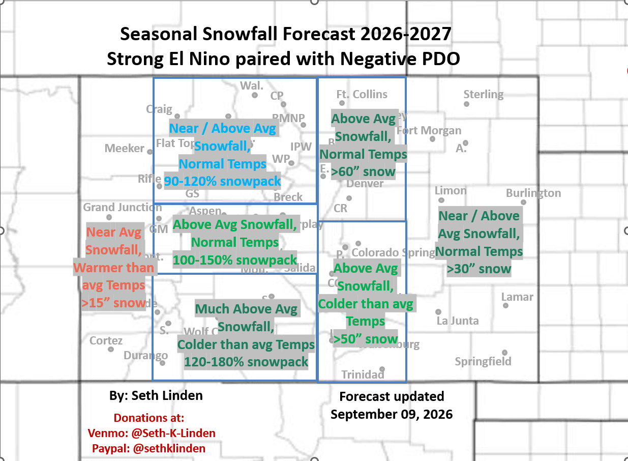
First, here are my headline predictions for the primary regions in CO. This is valid Oct 1st to May 1st
Northern Front Range (Den/Bou, Ft. Collins, Castle Rock, foothills): Above Average Snowfall, Near Normal Temps, >60” snow possible
Southern Front Range (Springs, Pueblo, Canon City, Trinidad): Above Average Snowfall, Colder than Average Temps, > 50” of snow possible
North-Central Mountains (RMNP, IPW, Winter Park, Loveland, A-Basin, Keystone, Copper, Vail, Beaver Creek, Steamboat): Near / Above Average Snowfall, Near Normal Temps, Snowpack could be 90-120% of average
South-Central Mountains (Aspen, Grand Mesa, Crested Butte, Monarch): Above Average Snowfall, Near Normal Temps, Snowpack could be: 100-150% of average
Southern Mountains (Telluride, Purgatory, Silverton, Wolf Creek, Sangres): Much Above Average Snowfall, Below Average Temps, Snowpack could be 120-180% of normal
Eastern Plains (Sterling, Limon, Burlington, Lamar, La Junta): Near to Above Average Snowfall, Normal Temps, > 30” of snow possible
Western Slope (Grand Junction, Meeker, Montrose, Cortez): Near Average Snowfall, Warmer than Average Temps, > 15” of snow possible
Ok, here are some details about the setup and best analogs for this season:
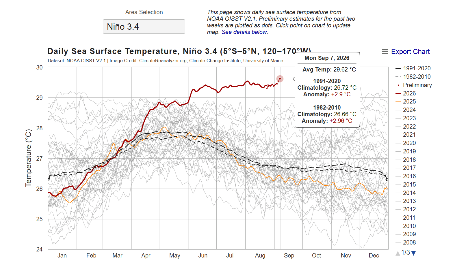
First and foremost we are looking at a record setting El Nino this season, in terms of the projected SST anomalies by mid-winter. Already a standard anomaly of + 2.9 degC in the Nino 3.4 region, with a projected peak of around + 3.6 degC by Dec/Jan (previous record peak was about +2.8 degC). So the strength of the El Nino alone is unprecedented.
Remember a strong El Nino supercharges the southern (subtropical branch) of the jet-stream and typically brings above average precip to areas like central / southern CA, AZ, NM, parts of UT and southern CO.
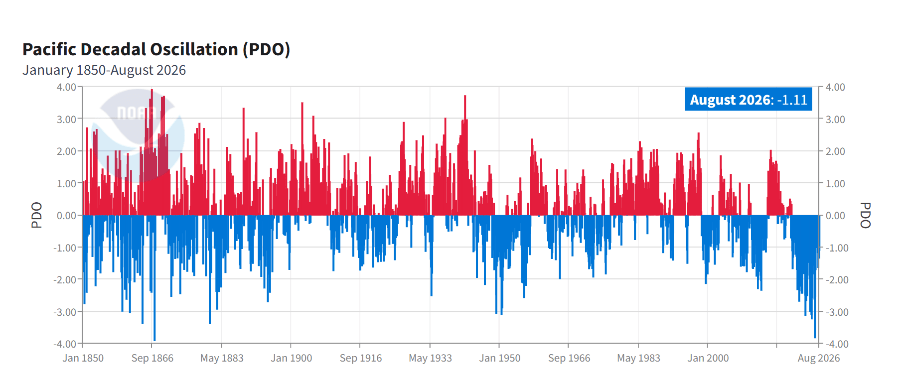
But we are also currently dealing with a prolonged negative PDO, which is currently at -1.1 degC, expected to remain somewhat negative to near neutral by Dec/Jan.
A note: the PDO describes a large-scale pattern of warmer and cooler ocean water across the North Pacific. The negative phase is associated with cooler water along much of the West Coast of Canada and warmer water in the central North Pacific (in the area generally southwest of AK).
Anyway, when you look at the 3 strongest El Nino’s on record: 82’-83’, 97’-98’ and 15’-16’ they basically all had positive PDO’s, although 82-83 was a bit of an exception.
Typically: A positive PDO with a strong El Nino amplifies the impacts of El Nino. A negative PDO with La Nina amplifies the impacts of La Nina. A strong El Nino and negative PDO represent conflicting North Pacific patterns.
In some respects a negative PDO provides more energy to the northern (polar) branch of the jet-stream, and allows for more cold-air to move into the U.S. from Canada (more like La Nina). But a negative PDO combined with a strong El Nino could be beneficial for northern CO (if the polar jet-stream can combine with deeper moisture from the south). So the negative PDO could moderate warmer and drier conditions further north (could be better for the north-central mountains, etc).
The negative PDO could also lead to more cold-fronts / arctic air for the front-range (Den/Bou) and this could also produce some bigger snow storms at times (if the cold-air combines with the southern track lows).
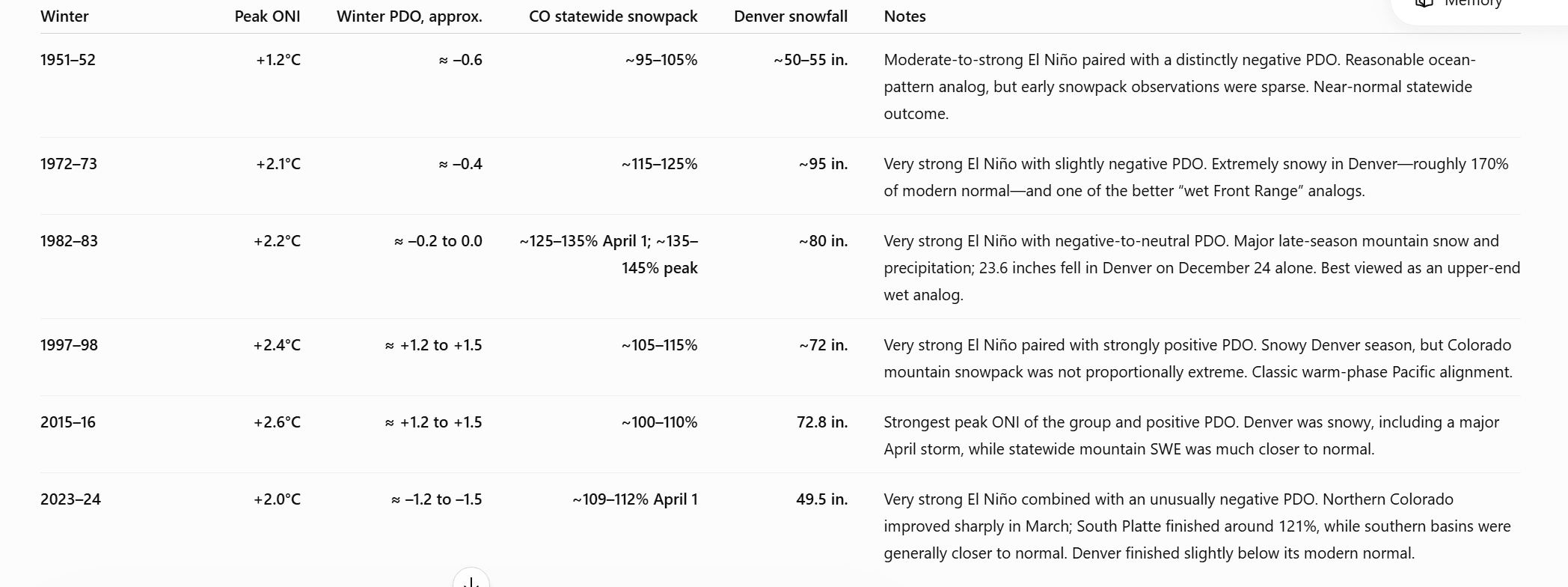
So instead of looking at the 3 strongest El Nino years, it's worth looking at some analogs with a moderate / strong El Nino coupled with a negative PDO (some of the info below is from Trevor G and other sources):
1951-1952: Moderate El Nino in fall, weakened to a standard El Nino by Winter. PDO was about -1.05 degC. The statewide snowpack was ~185% of average (northern mountains: 170% of average, southern mountains: 200% of average). Denver had ~85” of snow (142% of average)
1972-1973: Strong El Nino throughout winter (+ 1.8 degC) with a negative PDO in fall that eventually trended towards neutral by winter (could be similar this season). The statewide snowpack was ~120% of average (northern basins: 105%, southern basins: 130%). Loveland ski area had 437” of snow. Denver measured 95” of snow (168% of average).
2023-2024: This is probably the closest recent analog for the coexistence of a strong El Nino and persistently negative PDO. El Nino peaked at +2.0 degC and the PDO was -1.2 degC in Dec/Jan. The statewide snowpack ~109% of normal (northern CO: 108% of normal, southern CO about 100% of normal). Denver measured only 45” of snow (80% of normal).
Other analogs:1982-1983. a very strong El Nino (+ 2.2 degC) with a negative to neutral PDO. The statewide snowpack ended up at ~140% of average (including a very snowy Apr and May). Denver measured 82” (144% of normal)
1997-1998: a very strong El Nino (+ 2.4 degC). But the PDO was positive (+ 1.2 degC) Peak statewide snowpack of ~121%, Denver had 73” of snow (127% of average)
The main takeaways:
The pattern favors above average snow for southern CO (San Juans to Elks).
It also favors above average rain/snow for the front-range (including Den/Bou/Ft.Colins/Springs etc)
The north-central mountains are a bit of a wildcard (probably will be near/above normal, more than last season).
In general, I'm expecting the most active weather during the shoulders of the cold season: parts of fall: Oct, Nov, into early Dec. Then likely a less active pattern / lull mid-Dec through mid-Feb, then very active again for spring: from late Feb through Mar and Apr
Statewide Snowpack will likely finish above average (anchored by the southern mountains).
We can’t judge the results of the seasonal forecast until we get past May 1st
Lastly, as many of know: these season climate forecasts are uncertain and ripe for error. All it takes is a few big storms (or lack there of) to throw things off. But you at least have to try and I feel like it is really interesting climate science (and complicated for even this seasoned meteorologist).
Enjoy! Let me (or Trevor) know if you have any questions?
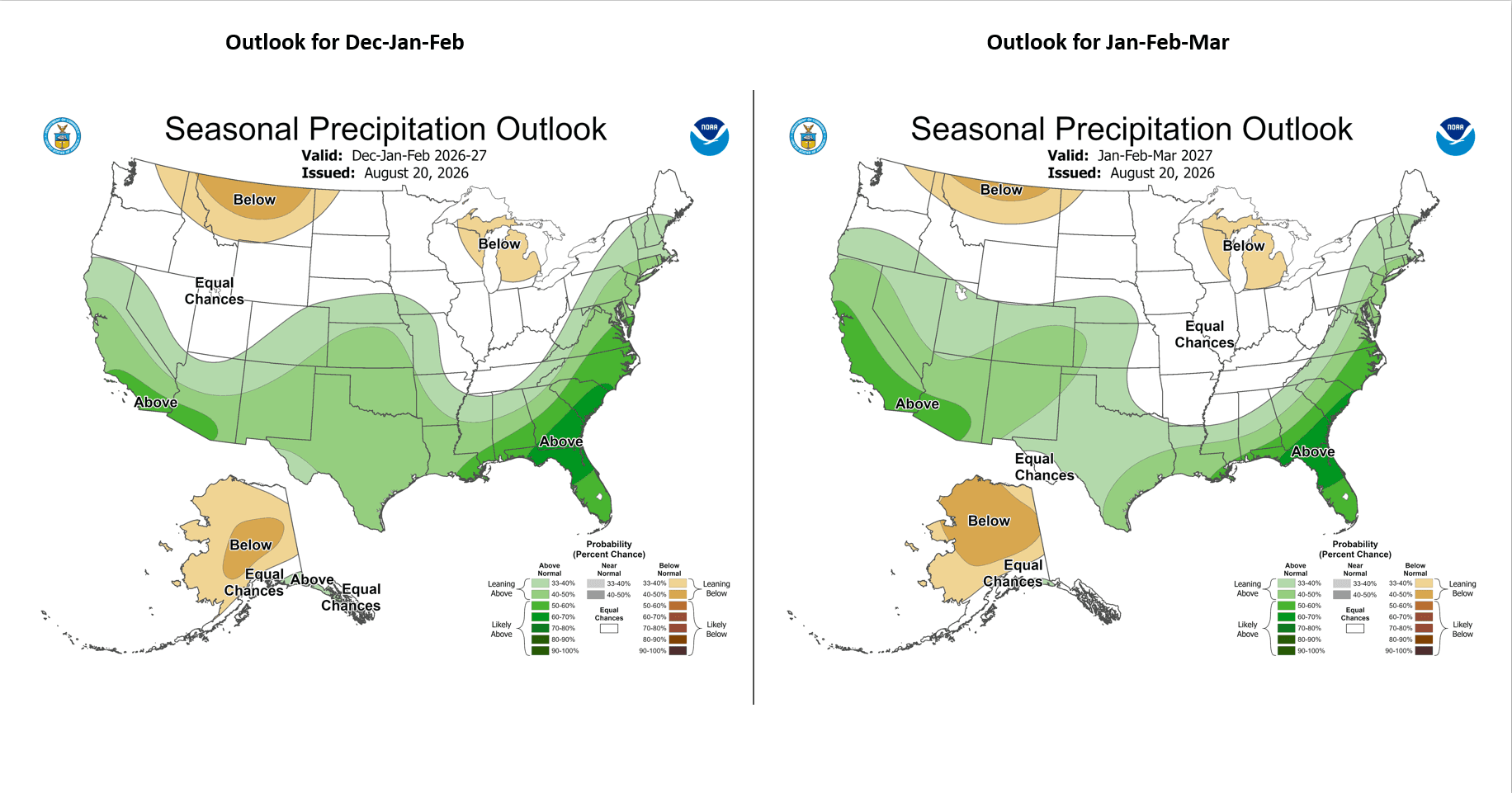
First image is my initial winter outlook for CO. Second image shows NOAA's Seasonal Precipitation Outlook for Dec-Jan-Feb and also Jan-Feb-Mar (some good signals for CO). Image 3 shows the current Nino 3.4 SST anomaly values (standard values, not averaged). Fourth image shows the current PDO phase. In the comments I'll post some images from Chat that breakdown snowpack and Denver snowfall for all the analogs and strong El Nino years.

Like what you read?
Receive daily weather reports straight to your inbox with Seth's Daily Newsletter. Sign up below.
