Updated rain/snow map for the Wed-Thu storm (which has shifted south: less precip for Den/Bou)
Sep 29, 2026
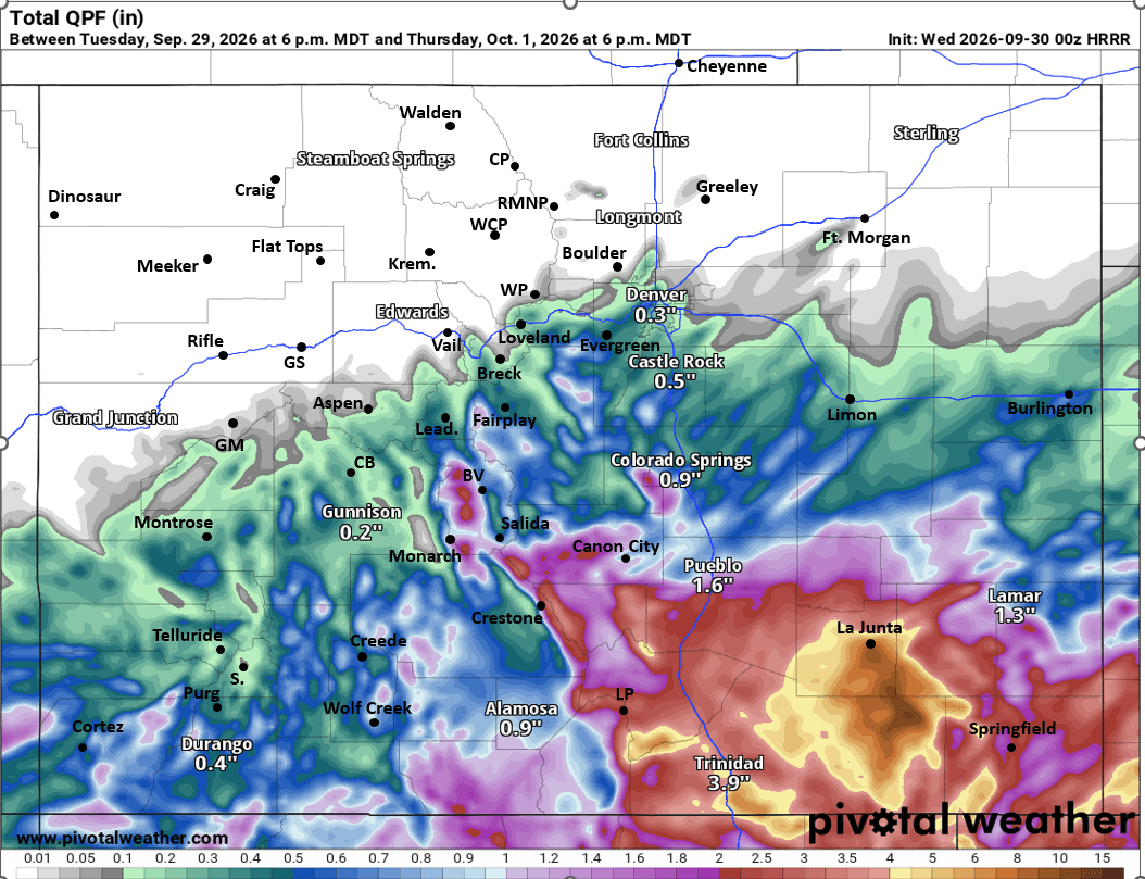
09/29/26 9pm: More of a formality at this point, since we know the trends (south) and its not going to be that exciting for northern CO, but wanted to post my updated total rainfall / snowfall map so I can look back and be more correct lol. I'll let the map mostly speak for itself.
Currently just some rain over southeast CO and that will be the area favored for the heaviest rainfall overall...in fact some of the latest models have 3-7" of rain for areas near Trinidad, La Junta, Lamar and Springfield, some big time flooding likely in those areas (Wed into Thu).
Also looks like the biggest snow totals will be in the Sangre De Cristos (10-16"+) and in parts of the Wet Mountains (4-8"+) above 10,500ft by Thu am.
Rain will move into the rest of southern CO / southern front-range (from Springs south, favoring areas closer to Pueblo and south) after 3am Wed and will continue through 3am Thu.
Some rain showers will spread into Den/Bou and parts of the northern front-range mostly from 12pm-8pm tomorrow. Maybe some decent amounts of 0.25-0.45" in spots, but mostly from Denver south to the Palmer Divide. Little to nothing expected north of Denver.
Foothills west/southwest of Denver will also get 0.25-0.60" in spots.
In the mountains, most of the action will be along/south of I-70 but some rain/snow showers for Summit, ClearCreek, Grand Counties from 10am-10pm Wed. Some light snow above 10,500ft: 1-4", favoring areas near/east of the Cont. Divide.
Some good rainfall for much of southwest CO as well (especially on top of what has already fallen) but generally 0.50-1.00" of additional rain (2-8" of snow for higher parts of the San Juans above 10,500 ft).
Storm clears out early Thu....
Then a gradual warm up into the weekend followed by a hot and dry stretch from about Fri, Oct2 through Fri Oct 9th (1 week or so). Not uncommon to get a break with sunny skies in part of Sep or Oct. But it does look hot again (likely in the upper 80s for Denver by Sun, sigh).
Then maybe after that (after Oct 10/11) a cold-front with better snow chances but that is so far out and we all know how bad the models have been lol.
That is all for now, hoping for some magical shift back to the north in the storm track 🙂
First image is my final rainfall/snowfall map for this storm. Image 2 shows forecast total liquid precip from now through 6pm Thu from latest HRRR model, third image is equivalent for total snowfall (take amounts with grain of salt). Fourth image shows the forecast hi/low temps for Boulder for the next 10 days from ECMWF. I will also post ECMWF total precip in the comments.




Like what you read?
Receive daily weather reports straight to your inbox with Seth's Daily Newsletter. Sign up below.
