Updated forecast for the weekend: looking drier overall, but still cool on Sun/Mon
Jun 11, 2026
06/11/26 9:30am: Well, the forecast is changing again for the weekend into early next week. Its unfortunately looking much drier overall, especially for northern CO and the front-range. Main issue is the models show the Sunday short-wave tracking further north and not phasing as much with the moisture coming up from the south.
Still will be turning cooler / cloudier for the front-range (Den/Bou) Sat-Mon, especially colder on Sun but not likely not much actual rain with this storm system. I think one of the issues will be that the cool air moving down the front-range on Sat into Sun will cause a bit of capping inversion and prevent much actual shower / thunderstorm development (we need warm air at the surface, relatively speaking, for thunderstorms and rain this time of year).
It now appears the focus for any meaningful rain on Sun into Mon will be over southern CO, mostly southeast CO (southern front-range and east).
In the mountains also not going to be much: some rain showers mostly over south-central CO (Collegiate Range to eastern San Juans to SLV to Sangres) on Sun into Mon. Further north, for much of the north-central mountains likely little rain.
Models now show a dry cold-front moving down the front-range on Saturday morning, this will cool down temps for Den/Bou on Sat, with highs only in the 70s, it will be warmer in the mountains on Sat.
On Sat evening (between 6pm Sat to 6am Sun) a chance for a few rain showers in the foothills west southwest of Denver and south towards Pikes Peak region (west of Springs), won't be much.
It will remain cool and cloudy on the front-range on Sun but likely not much precip.
Best chance for some rain showers for Den/Bou and the foothills will be 12pm-9pm on Sun, then again from 12pm-9pm on Mon. For Den/Bou maybe the best chances will be on Mon afternoon. Temps will be in the upper 60s on Sun and low 70s on Mon.
Best chances for rain will be over the southern front-range, from the Palmer Divide south on Sun afternoon and again Mon afternoon.
For the mountains a few rain showers near/east of the Cont. Divide and mostly south of I-70 late Sun afternoon, (after 3pm Sun) and a better chance on Mon: 12pm-8pm, won't be much.
So basically cooler Sun-Tue but not much rain now.
Good news we are official under El Nino conditions in the equatorial Pacific and its expected to be a strong El Nino by fall / winter (that should keep things active for much of CO this fall and winter)... I'll have more on that later.
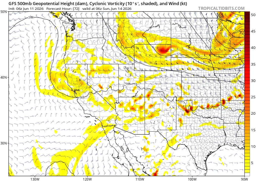
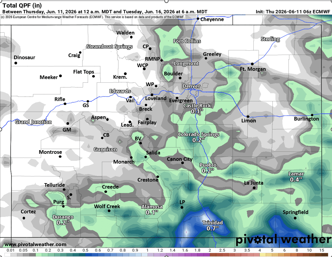
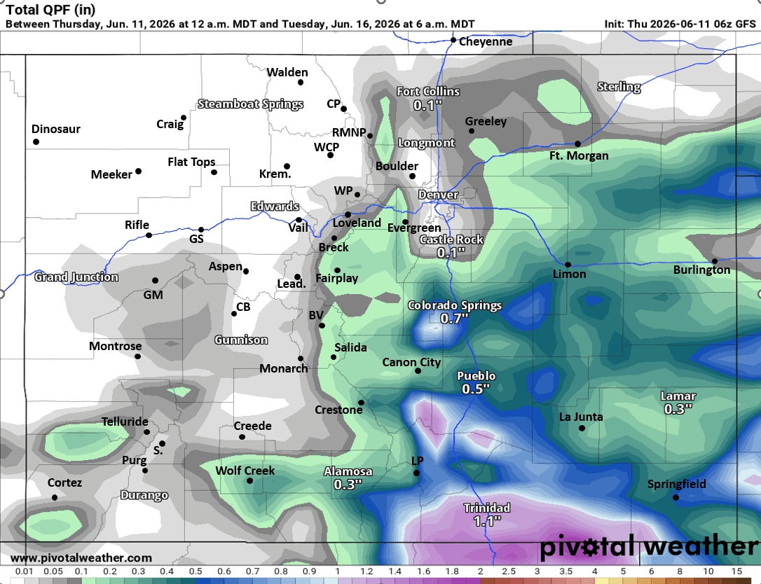
First image shows the short-wave trough, now much further north at 12am Sun via 500mb vorticity / wind from GFS. Images 3 and 4 compare forecast total liquid precip from now through 6am Tue from latest GFS and ECMWF models, take amounts with big grain of salt (as we are dealing with thunderstorms in spots).

Like what you read?
Receive daily weather reports straight to your inbox with Seth's Daily Newsletter. Sign up below.