Turning windy Wed. Some light snow for the mountains Wed night into Thu. A larger storm this weekend
Apr 20, 2026
04/20/26 8am: It's Monday, at least its 420 lol. Weather of immediate concern this week:
- Turning very windy across much of the state on Wed ahead of a short-wave.
- Some light snow for the northern mountains Wed night into Thu
- Rain/snow showers for the mountains Thu afternoon and Fri afternoon
- Tracking a potential larger and more impactful storm for Sun/Mon (04/26 to 04/27) with rain and snow for both the mountains and front-range
First very nice today and tomorrow with temps near/above 80 for Den/Bou and 60s/70s in the mountains. Light wind overall (some wind over the Front Range mountains).
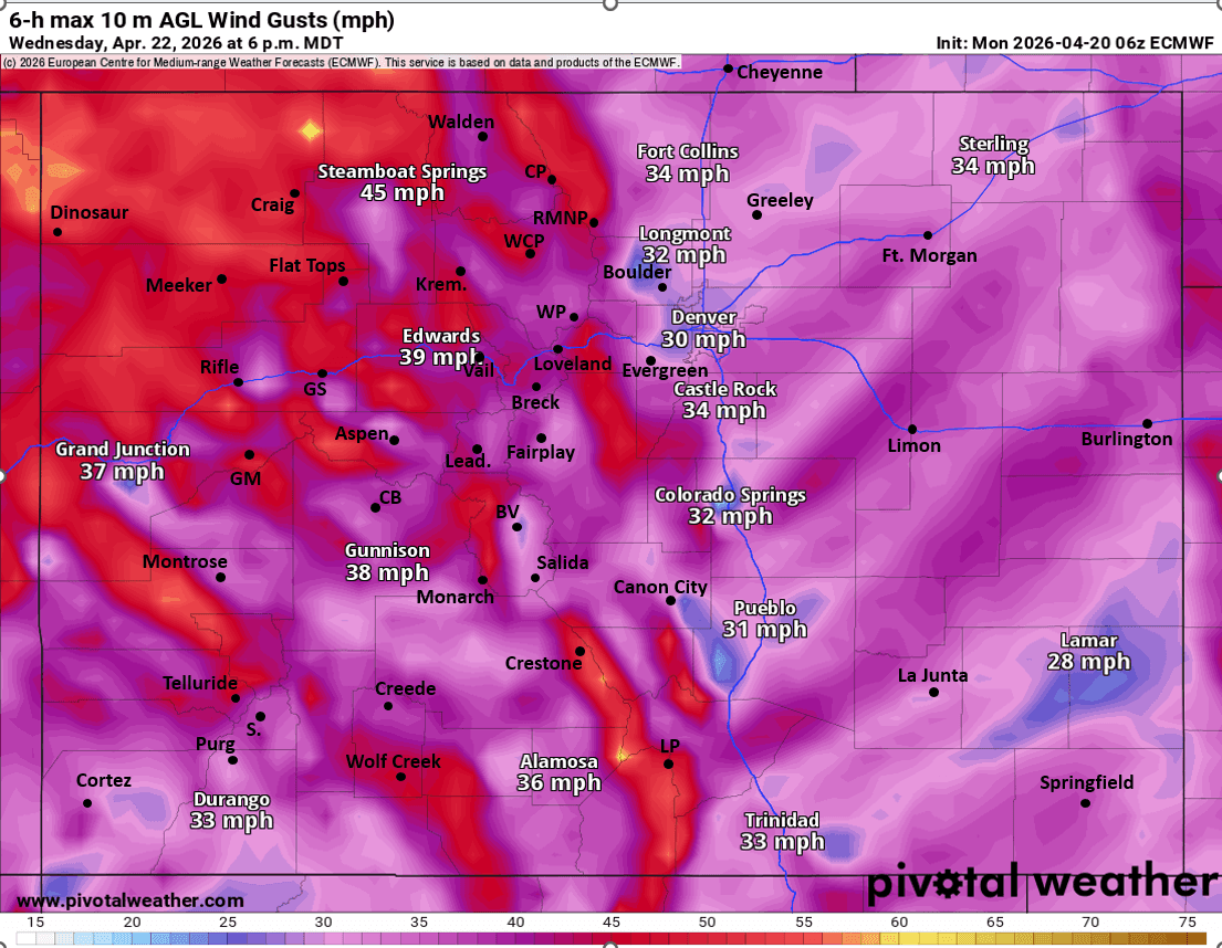
Then on Wed it will be turning windy over the mountains and front-range mostly from 9am-9pm Wed: westerly wind-gusts of 30-70 mph, strongest in the mountains near the Cont. Divide. Windy over Den/Bou (but gusts likely below 60).
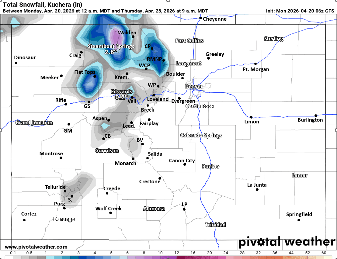
Some light snow returns to the north-central mountains mostly from 6pm Wed to 9am Thu (most of it early Thu am): 1/2" to 3" for the local ski areas and higher terrain (with up to 6" over the northern mountains: near Park Range and Medicine Bow Ranges)
On/off light rain and snow showers for the mountains on Thu and Fri, mostly in the afternoon each day, favoring northern CO.
Better rain/snow chances return to the mountains on Sat afternoon / evening.
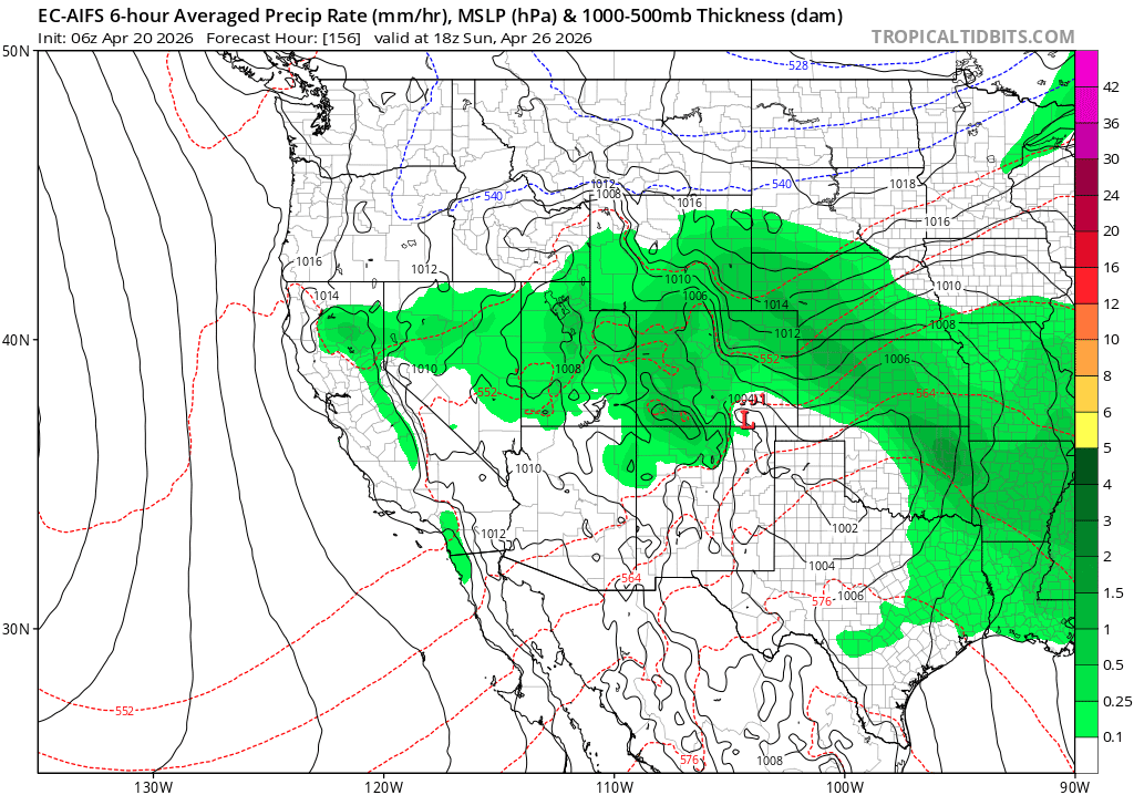
But models are really showing a much larger storm system (broad trough from the north combining with a short-wave / low from the south) on Sun into Mon but details are all over the place.
Mountain could get some moderate to heavy snowfall from 12am Sun through 6pm Mon, best chances Sun morning right now, or Mon am (depending on the model).
Den/Bou and the front-range could get some snow on Sun morning, or it may hold off until Sun night into Mon. Regardless looks cold enough and some of the models are cranking out quite a bit of precip (mostly in the form of snow). So heads up, we likely aren't done with the snow yet in Denver.
First image shows forecast total snowfall for the Wed/Thu wave valid 9am Thu from latest GFS, take with a grain of salt. Second image shows 6-hour max wind-gusts at 6pm Wed (12pm-6pm Wed) from latest ECMWF, going to be windy on Wed. Third image show the potential for a much larger storm system at 12pm Sun via ECMWF-AIFS (A.I. model) which is useful for gauging the long-term pattern.
Smoke em if you got em later. Green that is. Happy 420!

Like what you read?
Receive daily weather reports straight to your inbox with Seth's Daily Newsletter. Sign up below.