Some possibilities for the Thu/Fri storm system
Jan 6, 2026
01/06/25 8pm: Lets take a look at some possibilities for the next storm system, which looks complicated lol...but will eventually bring some of the coldest air of the season by late Thu into Fri and a good round of snow to much of the state.
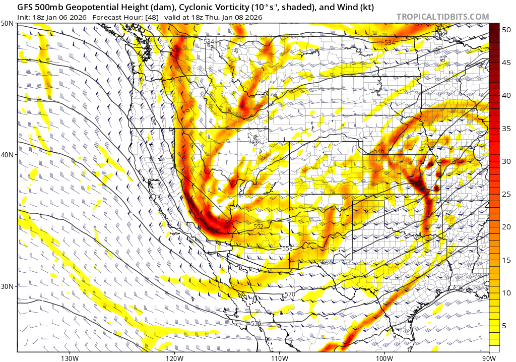
Models actually show two short-waves back-to-back which increases the uncertainty in the details (as the waves interact).
The first wave will bring snow to the mountains and foothills from late Wed night through Thu am. Then the main storm-system with the coldest air and strongest dynamics aloft will move through Thu night into Fri am (that will be the main round of snow).
Still big questions on how far south the main upper-level low tracks on Thu into Fri...some of the latest model trends have shifted the low a bit farther south with bigger impacts over southern / southeast CO. Others have it coming in further north, with bigger impacts more over north-central to northeast CO.
Most of the impacts for the mountains will be from 11pm Wed to 8am Fri
Most of the impacts for the front-range (Den/Bou/Ft.Collins, Springs, Pueblo, etc) will be from 11am Thu to 11am Fri
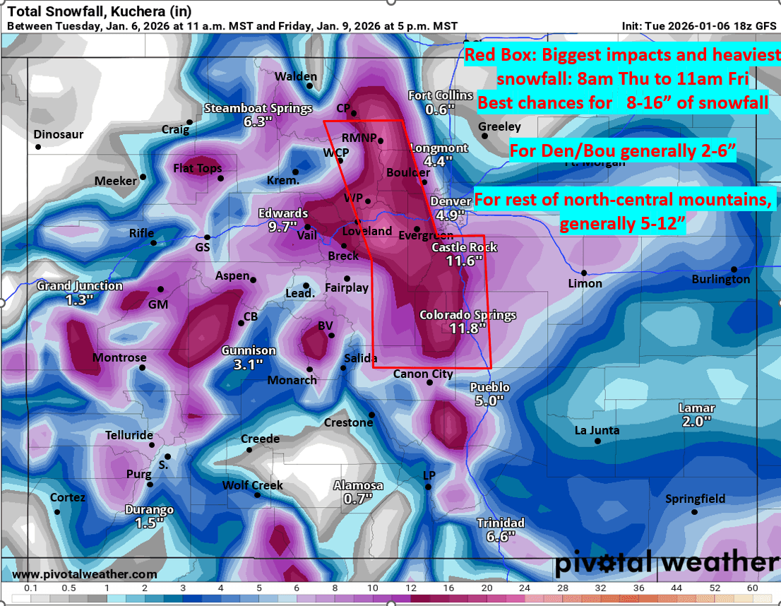
Best chance for heaviest snowfall will be in the front-range foothills from Nederland to Evergreen to Bailey to areas near Pikes Peak and also likely South Park area (near Fairplay) and maybe in/near Colorado Springs and the Palmer Divide as well. I circled the area on the map below (maybe 8-16" in those areas)
For Den/Bou and the northern front-range coldest air and best upslope flow comes in after 5pm Thu, so the main snow window will be 5pm Thu to 8am Fri (but there could be some snow showers as early as 8am Thu as the first short-wave moves through).
For Den/Bou looking like 2-6" of new snow with highest amounts near the foothills. Likely a sharp drop-off to the north, so only 1-4" for areas from Longmont to Loveland, Ft. Collins and Greeley areas.
For the north-central mountains / I-70 mountain corridor a complicated forecast as models show westerly flow with moderately cold temps with the first wave (Wed night into Thu am), then more upslope flow (north to northeast flow) from Thu mid-day through Th evening, then a shot of much colder northwest flow on the back-side of the trough (Thu night into Fri am), so this mix of windflow could affect totals and models are all over the place.
Highest totals in the mountains will be along/east of the Cont. Divide: So areas like Loveland, Berthoud, Winter Park, IPW, RMNP, etc may get 7-14" of new snow.
For the Summit Co. ski areas (A-Basin, Keystone, Breck, Copper, etc) likely 6-12" by Fri am
For Steamboat, Vail, Beaver Creek, likely 5-10" by Fri am (more uncertainty with the upslope flow)
Also looks like much of the Elk Range (Aspen, CB) and western and eastern San Juans (Silverton to Wolf Creek) will get at least 5-10" of snow as well (maybe > 12" in the Elk Range)
As I mentioned much colder in the mountains after 8pm Thu and especially on Fri (Friday will likely be the coldest day of the season with high temps in the single digits to teens but some cold smoke as well 🙂 )
Also cold on the front-range (Den/Bou) on Fri: temps in the upper 20s / low 30s.
That is all for now. Tonight into tomorrow, I'll be working on my snowfall forecast map. Need to see some more model consensus lol.
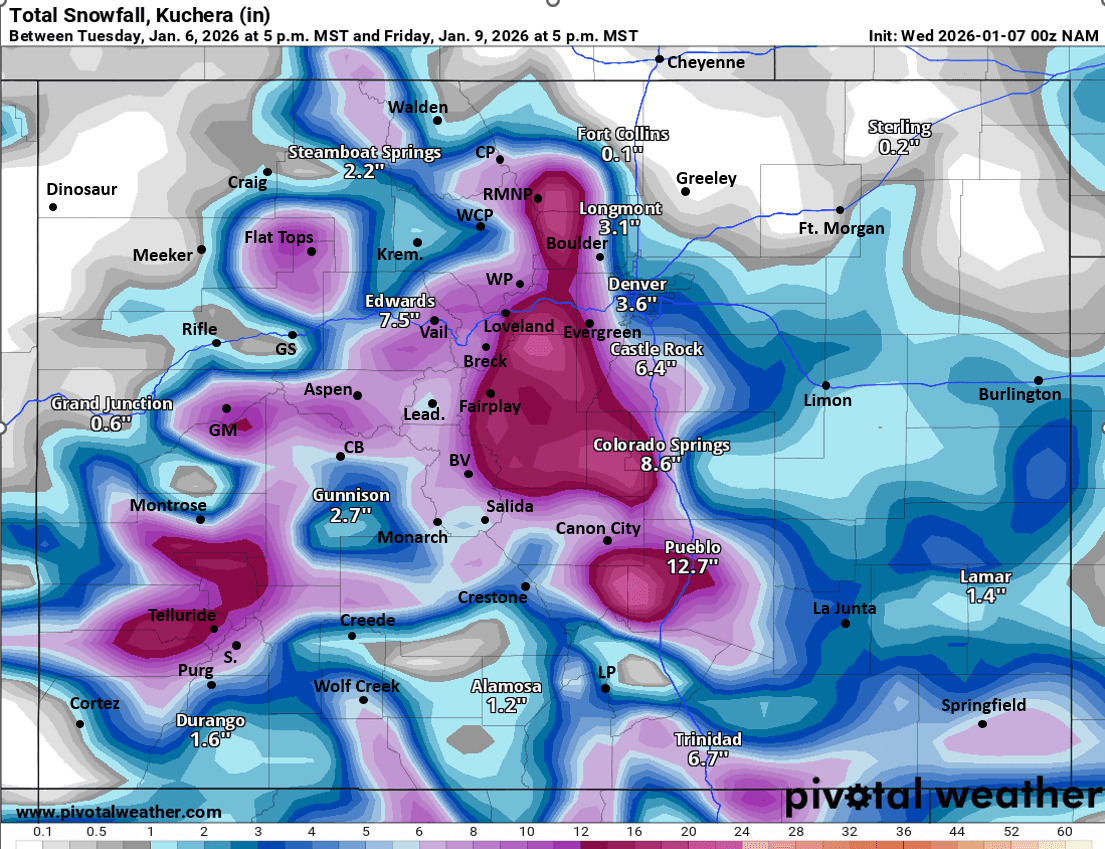
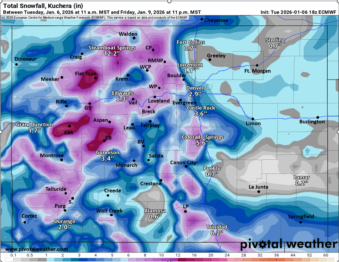
First image shows the complicated flow pattern with the two waves at 11am Thu via 500mb vorticity / wind from latest GFS. Images 2-4 compare forecast total snowfall from now through 11pm Fri from latest GFS (I show biggest impacts), latest NAM and ECMWF models...take modeled snowfall amounts with a big grain of salt, with these more low-res models the valley/mountain features are broad-brushed so the details will change some, just gives general idea.

Like what you read?
Receive daily weather reports straight to your inbox with Seth's Daily Newsletter. Sign up below.