Some impressive rain total over parts of the front-range already, with 2/3rds of the storm system to go
Oct 14, 2026
10/14/26 8:15am: Already some really nice rain totals on the front-range and across parts of southern CO this morning! Not much yet for the north-central mountains but we still have 2/3rds of the storm system to go (2 more parts of it coming up today and tomorrow).
Stoked that I measured 0.63" of rain already (the most in a long time). CoCoRaHS and MRMS reports show already a solid 0.50" to 1.10" for the western suburbs near Golden, Boulder, Arvada, Westminster, Broomfield, Lafayette to Erie area. And already a good 0.25" to 0.50" for much of Denver, Ft. Collins and the surrounding areas (with much more to come).
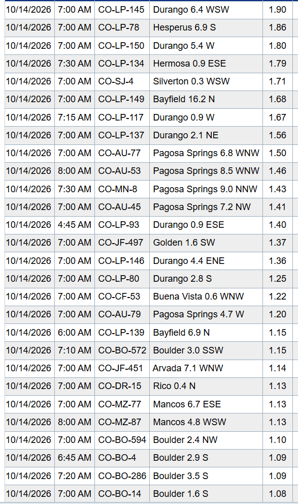
In the mountains, most of the action was over southern CO: part of Durango to Pagosa Springs to Wolf Creek picked up 1.40" to 1.90" of rain in just the last 24hrs.
In the central mountains: not much so far, spotty snowfall, but most of it will come later. Only 1/2" to 2" so far (for example A-Basin and Loveland are showing around 1" so far this morning).
But parts of the western San Juans (between Purgatory and Silveton) picked up 6-8" snow in the last 48hr. Wolf Creek looks like 1-3" so far at the base (maybe 6"+ up top)
Here are some top 24hr rain reports from CoCoRaHS:
Durango 6.4 WSW 1.90
Hesperus 6.9 S 1.86
Hermosa 0.9 ESE 1.79
Silverton 0.3 WSW 1.71
Bayfield 16.2 N 1.68
Pagosa Springs 6.8 WNW 1.50
Golden 1.6 SW 1.37
Buena Vista 0.6 WNW 1.22
Boulder 3.0 SSW 1.15
Arvada 7.1 WNW 1.14
Rico 0.4 N 1.13
Mancos 6.7 ESE 1.13
Here are a few more notable reports from the front-range:
Boulder 2.4 NW 1.10
Golden 1.2 E 1.00
Rollinsville 0.1 WNW 0.93
Evergreen 3.4 WNW 0.93
Louisville 1.2 NNW 0.81
Dumont 2.0 WNW 0.75
Lakewood 1.4 SE 0.74
Wheat Ridge 1.4 WSW 0.73
Erie 1.5 NNE 0.63
Estes Park 3.3 SSW 0.59
Littleton 2.5 W 0.51
Longmont 1.8 E 0.46
Loveland 4.0 SSW 0.42
Denver 0.2 NNW (Botanic G) 0.38
Fort Collins 3.7 NW 0.36
A few 24hr and 48hr snow reports
Powderhorn: 2"
Wolf Creek: 1-2" (6"+ up top)
A-Basin: 1"
Loveland 0.5"-1.0"
Keystone: 0.5"
Winter Park: Trace
Snotel:
Senator Beck (N. San Juans): 6.4" (8.7" 48hr)
Black Mesa (N. San Juans): 4.0" (7.0" 48hrs)
Middle Creek (S. San Juans): 3"
Taylor Pass (Collegiates): 1.3"
Independence Pass: 1.1"
Grizzly (Front Range): 1.0"
From yesterday (so we can keep track):
Beaver Creek: 2"
Vail: 1"
As I mentioned we really have 2 more parts of the storm system. The low is to our west.
Next round of rain/snow: from about 11am-8pm today, then a break
Last round from 3am-2pm Thu (colder, northwest flow).
I'll have much more later.
First image shows 24hr observed liquid precip (rain) from MRMS. Second image shows top 24hr reports from CoCoRaHS. Third image is a map snippet of 24hr reports over Den/Bou/Ft.Collins. Fourth image is current view of the A-Basin snow-stake.
How are conditions in your neck of the woods this morning?




Like what you read?
Receive daily weather reports straight to your inbox with Seth's Daily Newsletter. Sign up below.
