Some impressive 72hr rain totals already (and we have 3 more active weather days coming up)
Aug 13, 2026
08/13/26 8:45am: 72hr and 24hr rain reports below. Awesome to see the rain stacking up in spots over the last 3-days especially over parts of the north-central mountains and eastern plains! There was some heavy rain in spots yesterday and last night.
Thought it would be good to look at 3-day totals now, and then 3-day total by Saturday, so we can see the breadth of the 6-day event.
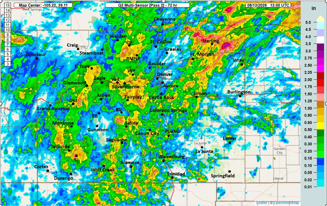
First image below shows 72hr totals from MRMS.
Part of the north-centra mountains near Eagle, Summit and Grand counties have picked up 0.50" to 1.25" of rain in the last 3-days
Parts of southern CO / San Juans have also picked up 0.50" to 1.50" of rain in spots.
Part of the northeast plains closer to Sterling have picked up 1-2" of rain already.
And parts of Denver/Boulder and the front-range urban corridor have picked up 0.05" to 0.45" in the last 3-days (with up to 0.75" already for parts of the foothills).
Even parts of Colorado Springs and southeast CO have picked up 0.25" to 0.75" in the last 3-days.
At my house, 0.07" in the last 24hr hours with 0.12" in the last 3-days, and that was about expected before the main events: Thu, Fri and Sat.
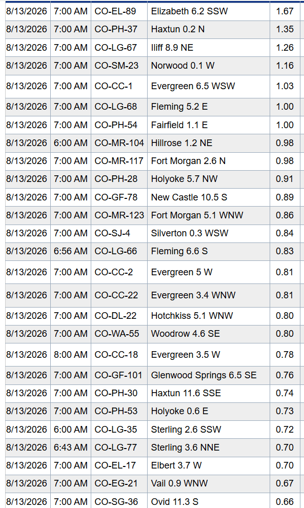
Here are some notable 24hr rain reports form CoCoRaHS this morning:
Elizabeth 6.2 SSW: 1.67"
Haxtun 0.2 N: 1.35"
Norwood 0.1 W (west of Telluride): 1.16"
Evergreen 6.5 WSW: 1.03"
Fort Morgan 2.6 N: 0.98"
Silverton 0.3 WSW: 0.84"
Glenwood Springs 6.5 SE: 0.76"
Vail 0.9 WNW: 0.67"
Edwards 0.5 E: 0.59"
Granby 7.7 N: 0.55"
Colorado Springs 5.0 NNE: 0.50"
Nederland 0.4 WNW: 0.40"
Centennial 2.2 SW: 0.32"
Golden 1.6 SW: 0.25"
Littleton 2.5 W: 0.21"
Arvada 3.1 NW: 0.20"
Denver 3.5 SE: 0.14"
Boulder 3.6 SSE: 0.08"
And its currently raining at my house. Latest radar shows a few showers moving through the northern front-range this morning (was pouring near Estes Park earlier).
Going to be an active 3-days, good storm chances from 1pm-10pm each day, best chances after 4pm, I'll have more soon.
I'm stoked on all this rain for the mountains already, and we have 3 more days to go (which should favor the front-range more, conditional on the cap as I mentioned).
I'll have more later.
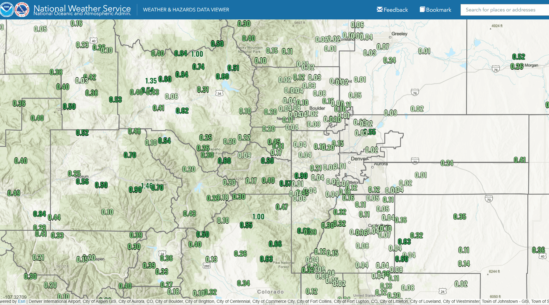
First image is 72hr observed rainfall from MRMS. Second image shows 72hr rain reports from NWS hazard viewer (some or not official stations). Image 3 is a CoCoRaHS map snippet over north-central CO showing 24hr reports and fourth image is a list of top 24hr reports from CoCoRaHS this morning.
How much rain did you get yesterday? Over the last 3-days?


Like what you read?
Receive daily weather reports straight to your inbox with Seth's Daily Newsletter. Sign up below.
