First day of astronomical fall. Some forecast details through Thu am as the weather turns active
Sep 22, 2026
09/22/26 8am: Happy first day of astronomical fall (the fall equinox is at 5pm today). It feels like fall out there this morning, with some seasonably chilly temps (45 at my house in Westminster, 24 in Fraser / Winter Park this morning).
Anyway, the active weather I mentioned last night, really starts today with a round of storms for the mountains and front-range, with much more on the way for Wed into Thu, favoring southern CO.
Some details for the next few days:
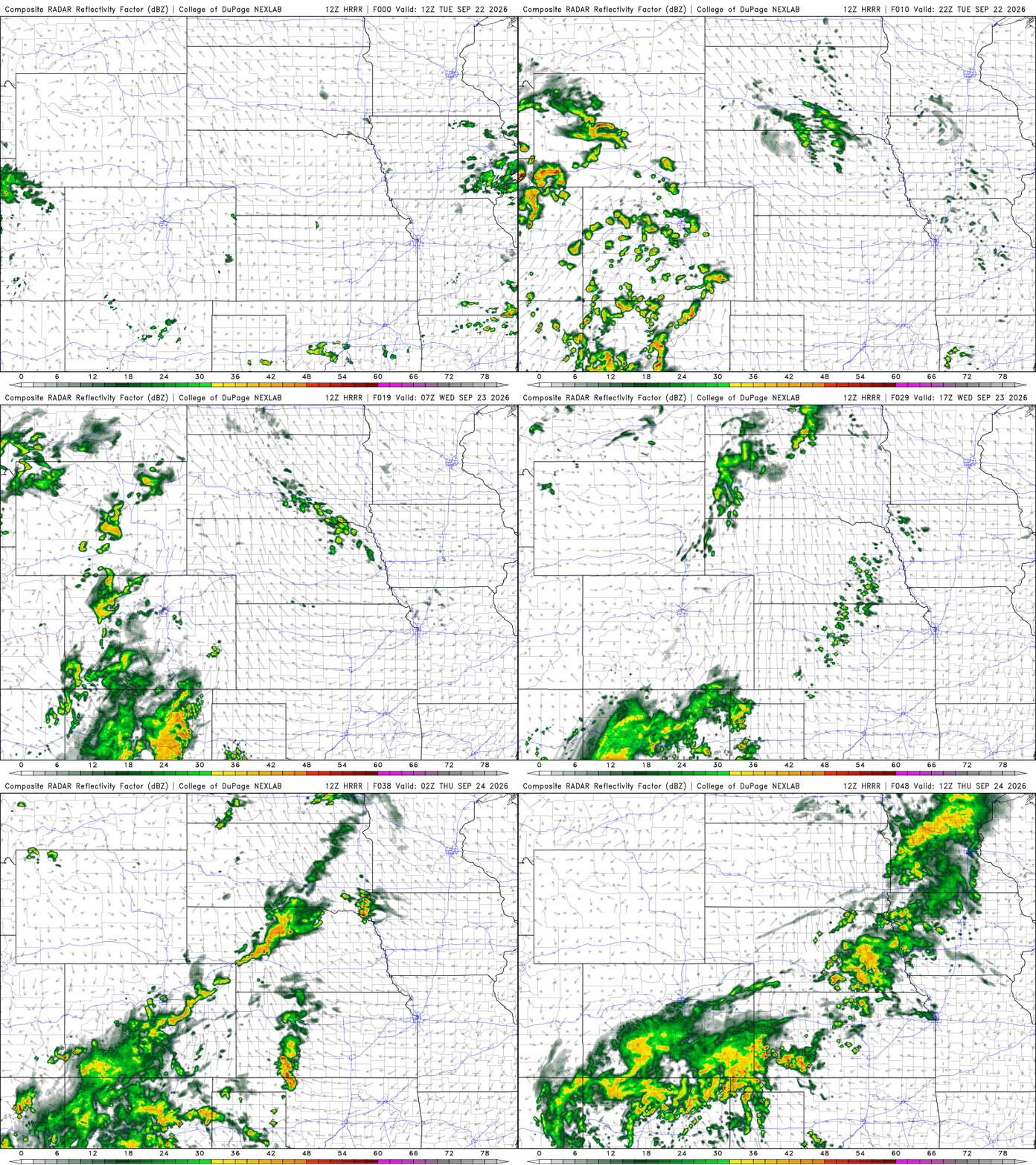
For both the north-central and south-central / southwest mountains today: some rounds of scattered thunderstorms, mostly from 1pm today through 1am tomorrow morning. Heaviest rain in the San Juans, after 3pm today.
Den/Bou and the front-range will have a chance for isolated to scattered thunderstorms from 2pm-8pm, best chances around the edges of the metro area: foothills, Palmer Divide and just east of Denver will have best chances for a few storms after 4pm.
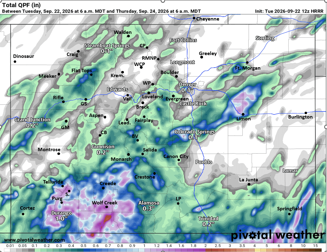
Then more consistent rain moves into southern CO after 12pm Wed. Southern / southwest CO: San Juans to SLV to Sangres will basically have on/off rain showers and thunderstorms from 12pm Wed through 6pm Thu with some heavy rain in spots (some snow above 12k ft on Wed night into Thu am). It will be wet in the San Juans.
For the rest of the north-central and south-central mountains on Wed (including the I-70 mountain corridor): scattered storms from 2pm-10pm, with best chances along/south of I-70 on Wed afternoon.
Then as I mentioned last night, more rain across much of the mountains during the day on Thu, starting in the morning and continuing through afternoon, again favoring southern CO for heaviest rain amounts (generally south of a Leadville to Grand Mesa line: favoring San Juans and Elks), but all of the mountains will have rain on Thu.
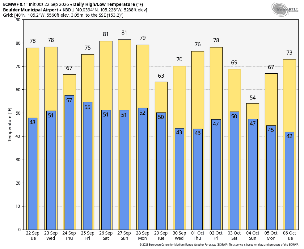
Den/Bou will also have a chance for light rain during the day Thu (starting in the morning) it will be mostly cloudy, pretty socked in and much cooler on Thu (highs only in the mid-60s), but limited rain amounts (probably will be pretty capped).
A break Thu night into Fri am before more rounds of thunderstorms on Fri afternoon (favoring the mountains, but also a chance for the front-range) from 1pm-9pm on Fri.
First image loop shows forecast radar over the next 48hrs (6am this morning to 6am Thu) from latest HRRR model. Second image shows forecast total liquid precip over just the next 48hrs (through 6am Thu: this is just the front-end of the event, does not include the main event on Thu). And third image shows forecast max/min temps for Boulder from latest ECMWF....
On a side note watching October 4-6th for some colder air and better snow chances across the state!

Like what you read?
Receive daily weather reports straight to your inbox with Seth's Daily Newsletter. Sign up below.
