Some extreme rainfall totals over southwest CO in the last 48hr (> 6" in spots) with some flooding near Pagosa Springs
Oct 23, 2026
10/23/26 9:10am: Happy Friday! Some ridiculous 48hr rain totals in southwest CO along with some major flooding in spots near Pagosa Springs.
First image below shows 48hr rain totals from MRMS. I had to change the scale there was so much rain... All areas in red have picked up > 2" of rain, Areas in purple > 4" of rain and a few areas in white > 6" of rain (near Wolf Creek Pass to above Pagosa Springs), wild!
Some crazy headlines this morning across that region (some of this I saw from other CO meteorologist this morning).
In Pagosa Springs > 3.10" of rain in the last 24hrs, with 5.21" in a few spots in the last 48hrs! (wide-swath of 4-5" of rain). Part of Pagosa Springs have picked up > 10" of rain since Sep 1st (that is insane).
Per Chris B this morning: "San Juan River in Pagosa with its 2nd-highest peak on record this morning (15 ft), highest since 1911."
Even my hometown in Alamosa has had record breaking rain the last couple of days, and mind you its usually pretty dry there.
Yesterday, Alamosa broke its all-time daily rainfall record with 1.67" at the airport (2.11" in the last 48hrs, some stations > 2.22"). Alamosa has now set its all-time October precip record with 2.55" of rain for the month (that is 2.07" above normal, and Alamosa only average about 7.5" of precip per year).
And finally good to see 0.25" to 1.25" across much of western CO and parts of the mountains (from GJ to Glenwood to Avon to Leadvile to BV, etc)
For Den/Bou only a measly 0.02" to 0.05" in a few spots.
In terms of snow, the snow-line stayed pretty high, mostly above 11,500ft.
Some of the SNOTELs above Telluride, above Silverton above Lake City and above Wolf Creek did record about 3-8" of new snow in the last 24hrs (and 6-12"+ in the last 48hrs). Fourth image below shows 48hr snowfall via CAIC station reports (mostly SNOTEL).
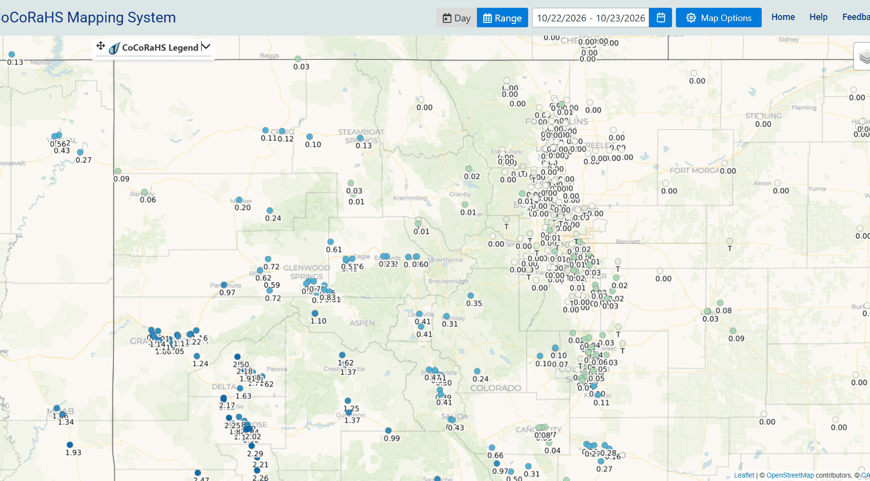
Anyway, here are some notable 48hr totals from CoCoRaHS:
Pagosa Springs 7.2 NW 5.21
South Fork 0.6 S 4.46
Chromo 3.9 E 4.28
Del Norte 8.6 SSW 4.15
Dolores 16.8 ENE 3.88
Rockwood 6.9 NNW 3.67
Yellow Jacket 1.5 NW 3.44
Ridgway 0.6 SW 3.32
Bayfield 16.2 N 3.27
Hermosa 0.9 ESE 3.19
Durango 7.2 N 3.15
Dove Creek 12.4 SSW 2.97
Redvale 22.8 SW 2.74
Capulin 2.9 ENE 2.61
Ignacio 1.5 N 2.54
Alamosa 1.2 NE 2.22
Montrose 3.2 SSE 1.99
Gunnison 0.2 NW 1.40
Grand Junction 4.1 ENE 1.11
Carbondale 3.5 ENE: 0.83
Rifle 8.9 NE 0.72
Gypsum 1.0 SW 0.51
Buena Vista 4.0 WNW 0.47
Salida 2.0 S 0.43
Pueblo 1.9 N 0.28
Edwards 1.3 WNW: 0.23
We will have a break in the action today for the most parts, especially over northern / central CO where it will stay dry through today.
Some thunderstorms and rain move back into southern CO: 2pm-8pm, mostly south of a Telluride to Silverton to Wolf Creek to Alamosa to La Veta Pass line.
More rain/snow moves back into the state tomorrow with colder / wetter impacts on Sun into Mon, all I have more on that later.
If you are in southern CO, how much rain did you get at your place? Any flooding?
You know what is crazy, I'm just remembering this now, that last October we had a similar event in the San Juans with 6-10" of rain in October down there and some flooding (this year is even worse with even bigger totals).
First image shows 48hr observed rainfall from MRMS. Second image shows 48hr reports from CoCoRaHS over southwest CO, third image is over much of western CO. Fourth image shows SNOTEL snow totals via CAIC.




Like what you read?
Receive daily weather reports straight to your inbox with Seth's Daily Newsletter. Sign up below.
