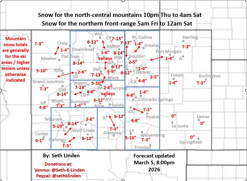
Snowfall map for the Thu night to Sat am storm system
Mar 5, 2026
03/05/26 8:15pm: Hi, hope you are having a good evening. I'm getting excited for the snow (but not the drive to the mountains tomorrow afternoon lol). Forecast is on track with just a few small changes. My updated snowfall map below.
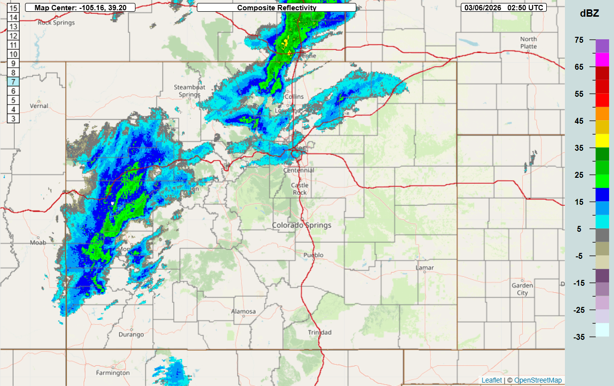
Current composite radar shows rain/snow moving into western CO now along with some upslope rain/snow developing over the northern front-range (near Red Feather Lakes now).
Still looking like a fairly potent early spring storm system for CO with most of the impacts from 11pm tonight to 11pm Fri (some snow lingers into Sat am).
In fact models have increased total precip / snow amounts a bit for Den/Bou and the front-range. I have kept my totals mostly the same since there is some uncertainty.
Looks like we could get a round of heavy snow in Den/Bou from about 6am-12pm tomorrow with more light snow lingering into Fri evening. Still looking at 1-5" for the metro area with highest amounts west of I-25 (western and southern suburbs), mostly on grassy surfaces. Refer to map.
Some of the models shifted the heavier snow a little north, maybe closer to Ft. Collins / Loveland areas but much more uncertainty there as other models show less up there, so I left it unchanged 1-4".
Still looks like the heaviest snow will be in the foothills west of Den/Bou/Ft.Colllins above 7k ft (Peak to Peak areas to Idaho Springs/Georgetown to Evergreen to Bailey, etc): 6-13" for those areas.
For the Palmer Divide, Pikes Peak region / Woodland Park a good 4-8". Also looks like 1-4" for Springs as well (could be more depending on how the low swings through).
Interesting setup in the mountains, as I mentioned yesterday the dichotomy: west-side of the storm system: from Beaver Creek west to Aspen and Grand Mesa and even parts of the San Juans (Silverton to Wolf Creek) will be favored for some heavier snow: 7-13".
Then a focus on the Front Range mountains east of the Cont. Divide with upslope flow in place: 6-12" (Loveland ski, Berthoud, Pass, IPW, RMNP, etc).
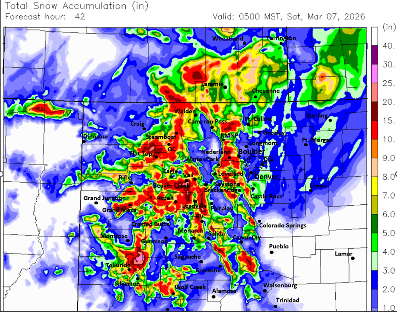
That leaves parts of Summit, Clear Creek and Grand counties in a bit of no-mans land (with the wind-flow), still decent totals but maybe less 4-10" or more depends lol. Notice on the CAIC WRF snowfall map how it has a very sharp downslope hole in middle of Grand and Summit counties and other areas (we will see if that actually verifies, might be overdone, but you get the drift)...
Some of the models show the best snow accumulation in the north-central mountains (for Summit, Grand counties etc) from 2pm Fri to 2am Sat as the colder air and better northwest flow comes in on the back-side of the trough.
Also some models have snow showers lingering along the front-range especially in the foothills through early Sat am.
In terms of wind, not that windy overall in the mountains with this storm system.
For Den/Bou and the front-range looks like some stronger wind-gusts between 9am-5pm Fri as the colder air comes in: northeast wind-gusts of 15-30mph...could be nasty in spots tomorrow morning.
Ready for some snow!
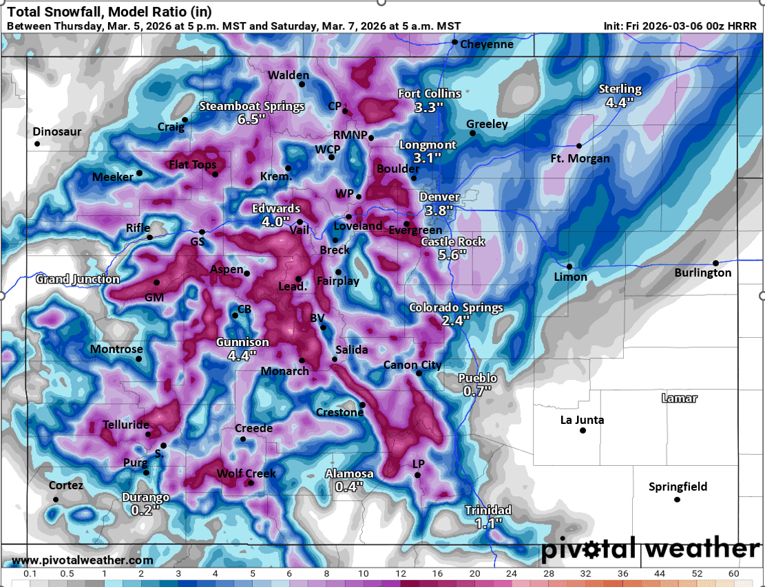
First image is my final total snowfall map from now through 5am Sat. Image 2 is current composite radar over the state. Images 3 and 4 compare forecast total snowfall from now through 5am Sat from latest 00z HRRR and 18z CAIC WRF 2km model, take amounts with grain of salt but you get the drift. I'll attach some more model snowfall maps in the comments.

Like what you read?
Receive daily weather reports straight to your inbox with Seth's Daily Newsletter. Sign up below.