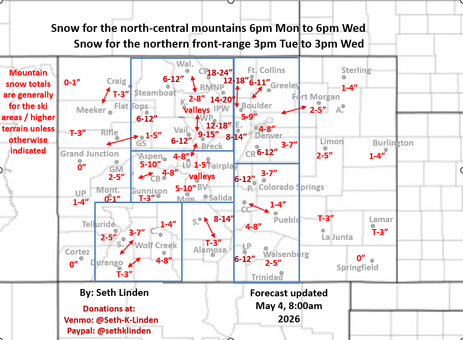
Snowfall map for the potent Tue/Wed winter-like storm system
May 4, 2026
05/04/26 9am: Alright, here we go! Major spring snow storm on track to impact CO from 6pm tonight through 6pm Wed with biggest impacts expected Tue night through midday Wed (with some heavy snow in spots).
Forecast remains on track and models are surprisingly consistent and have not backed down on precip amounts. I made a snowfall forecast map based on all the latest model data (a consensus of model data in my head, using local knowledge of the terrain).
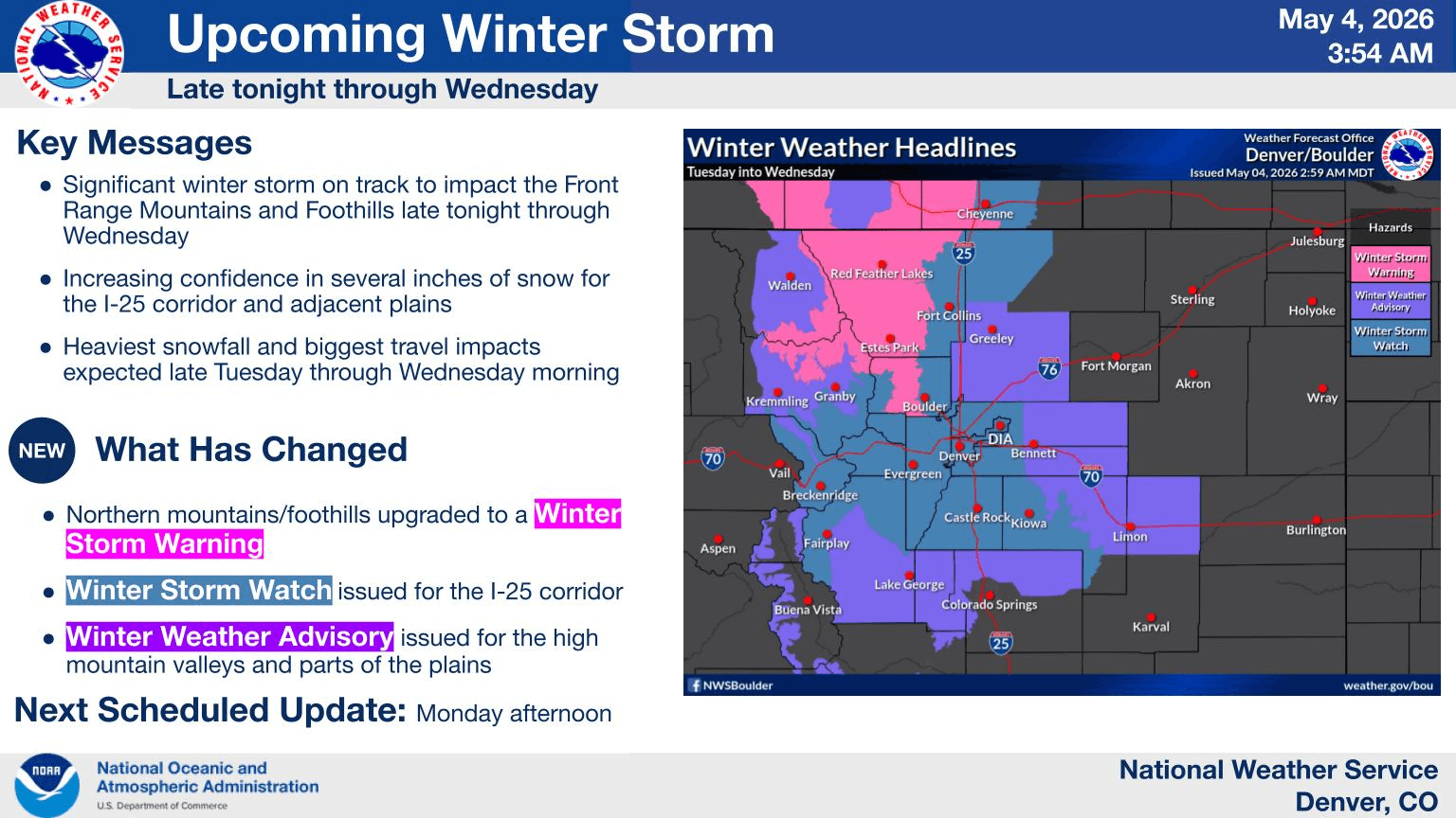
NWS is on board with lots of winter weather advisories and warnings this morning.
The northern foothills and mountains are under a Winter Storm Warning from 12am Tue to 3pm Wed.
Denver/Boulder, adjacent foothills and much of the front-range urban corridor and mountains are under a Winter Storm Watch from 8pm Tue to 3pm Wed.
Areas just east of the front-range, parts of the eastern plains from Greeley to Limon are under a Winter Weather Advisory from 8pm Tue to 5pm Wed (similar for areas closer to Pikes Peak, Fairplay and Monarch, an advisory there as well).
Still a bit of uncertainty in exact amounts, but you can see a big event is expected for the northern front-range mountains and foothills above 7k ft.
The foothills and mountains in Boulder and Larimer counties above 7k ft will be favored for the highest amounts (2.0-2.5" liquid with 12-20" of new snow with up to 2ft in spots)
The rest of the foothills west/southwest of Denver (in Jefferson, ClearCreek, counties, I-70 foothills corridor etc) can expect 8-16" of new snow. Refer to map.
On the front-range, areas near Ft. Collins, Loveland, Lyons, Longmont and west will be favored for 1.50-2.25" of liquid and 6-11" of snow for lower elevations.
Den/Bou can generally expect: 0.75-1.25" of liquid and 4-10" of new snow with highest amounts in western and southern suburbs (west of I-25) above 5500ft will be favored. 6-12"+ for the Palmer Divide as well.
For the north-central mountains including Summit, ClearCreek, Grand counties, etc, also a good snow event with generally 8-18", favoring the front-range mountains (closer to Loveland, Jones/Berthoud Passes, Grays/Torreys, Winter Park, IPW, RMNP,. etc).
A bit less closer to Vail, Beaver Creek and Steamboat ski area (6-12" for those areas).
First for today, scattered rain showers (and rain/snow showers in the mountains) develop after 1pm. Some showers in spots both for the mountains and front-range (Den/Bou) from 2pm-9pm today ahead of the main system.
More consistent cold-rain develops along the front-range tomorrow morning after 12am, favoring areas near the CO/WY border (closer to Ft. Collins, etc, some snow may mix in).
Then rain/snow spreads into Den/Bou by mid-day Tue.
All snow likely for Den/Bou from about 6pm Tue through 12pm Wed, heaviest snow expected late Tue night / early Wed morning and that is when road conditions will be the worse.
Heaviest snow overall will be Wed am across the mountains and front-range so heads up there. Could be delays traveling (both by car and plane).
Snow lingers in southern CO through Wed pm. The storm clears out late Wed night.
Protect exposed pipes, hoses and plants on Tue night into Wed morning (and maybe Wed night into Thu morning as well).
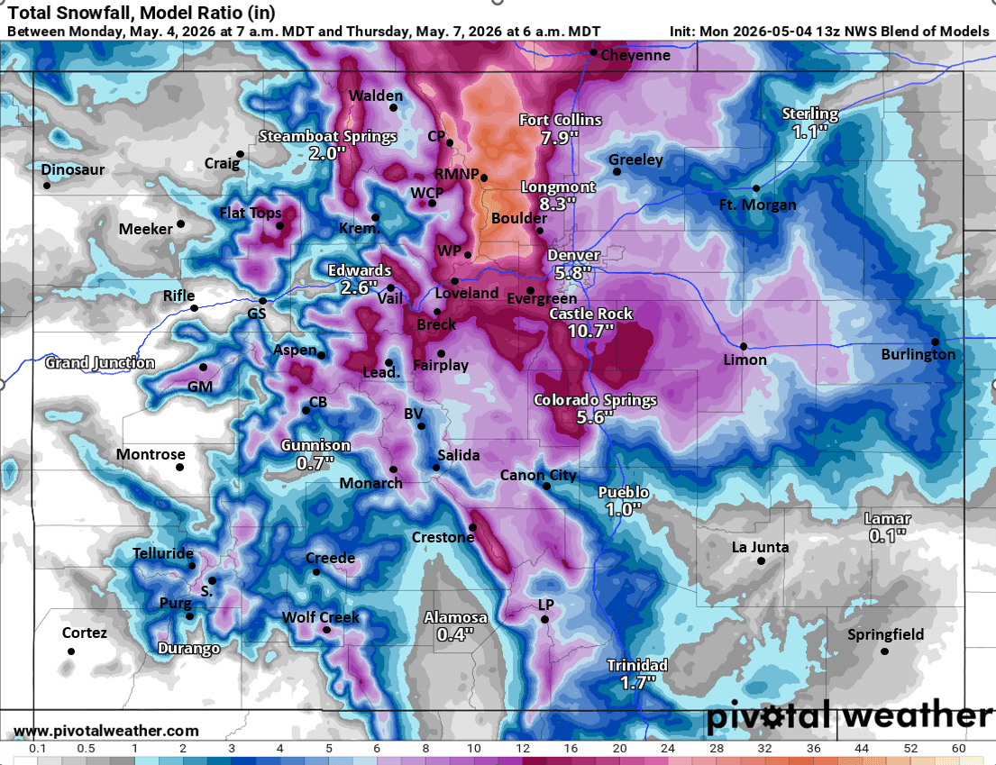
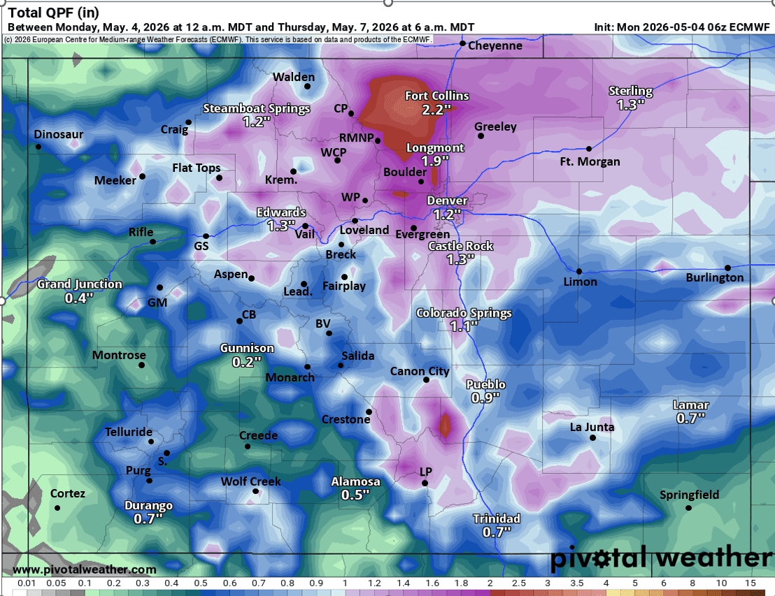
First image is my preliminary snowfall forecast map through 6pm Wed. Second image shows all the winter weather highlights from the Den/Bou NWS office. Third image shows forecast total snowfall from now through 6am Thu from very latest NWS Blend of Models (take amounts with grain of salt). Fourth image shows forecast total liquid precip from now through 6am Thu from latest ECMWF model (you can see where the bullseye will be).
Getting excited. Fingers crossed!

Like what you read?
Receive daily weather reports straight to your inbox with Seth's Daily Newsletter. Sign up below.