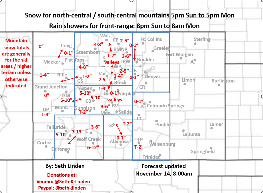
Snowfall forecast map for the Sun/Mon storm system
Nov 14, 2025
11/14/25 8:45am: Morning, happy Friday. Warm and windy out there this morning along the front-range, already 67 degs at my house on Nov 14th at 8:30am...its warm. Another warm day on tap with some wind. But we do have some changes on the way with a storm system still on tap to impact the state from mid-day Sun through Mon evening.
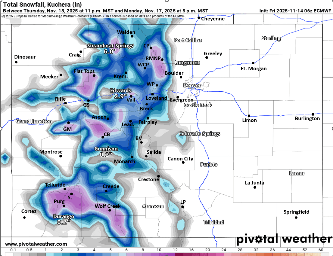
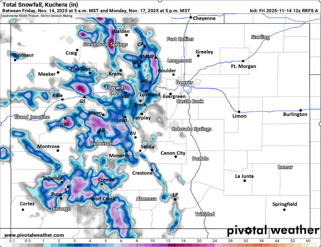
I had some time last night and this morning to make a snowfall map for you (see below). Now, my current confidence in the numbers is not great, due to the fact that the models show more of a split system as it moves across CO...this typically leads to bit less energy / precip in spots and uncertainty in where the heaviest snow will fall. Below is my best guess based on latest model data. As we move toward Sat and Sun we will get in range of the more high-res models (although I did include the lates RRFS, which will replace the NAM soon)
I'll the map mostly speak for its self. But here are some main points
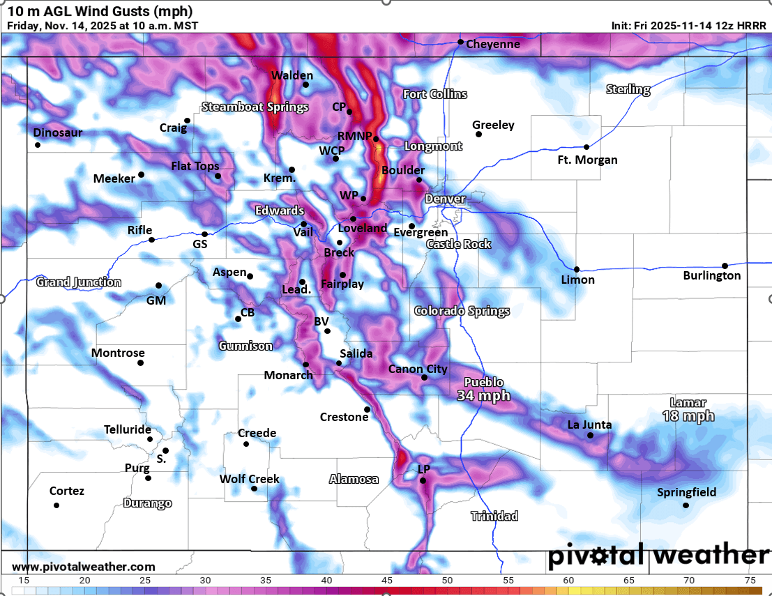
Warm and windy today, with windiest conditions over the northern front-range mountains and foothills: westerly wind-gusts of 30-50mph (for Den/Bou and the urban corridor: gusts of 20-40 mph).
Rain/snow moves back into southwest CO / San Juand by 11am Sun.
Rain/snow showers move back into the north-central mountains after 2pm Sun.
The main snow event for the north-central and south-central mountains will be 5pm Sun to 5pm Mon, heaviest Mon morning
A relatively warmer storm system overall. Snow levels will initially be around 9500ft on Sun / Sun evening, falling to 7500ft by Mon morning (but could be a rain/snow mix below this)
Heaviest snow still expected in the San Juans nears Telluride, Silverton, Purgatory and Wolf Creek: 6-13" down there (above 9kft), with heaviest snow likely above Silverton
Secondary highest amounts in the Elk Range between CB and Aspen: 5-10" there, and near Flat Tops and Park Range near/north of Steamboat ski area (4-8" for those areas), mostly above 8k ft
For the I-70 mountain corridor and the local ski areas (BC, Vail, Copper, Breck, Keystone, A-Basin, Loveland, WP, etc), generally 1-5" with highest amounts expected west of Vail Pass (Vail, BC) and also near/north of Winter Park (IPW, RMNP). Higher uncertainty for the ski areas in Summit Co based on the flow (some models show more), refer to map
For Den/Bou and the front-range not a big event (with quite a bit of westerly downslope flow expected) but some rain showers likely, with best chances from 8pm Sun to 8am Mon, best coverage from Denver north and maybe east of I-25 (if we have the stronger westerly wind). Maybe a few snow showers in the foothills above 8kf early Mon am, but won't be much
Snow showers may linger in the northern mountains on Mon night
Looking ahead, models are all over the place for next week's storm system between Tue-Thu (11/18-11/20) latest model runs now show the main low tracking too far south for any big impacts and not looking great for snowfall in Den/Bou now at least for that storm (we may have to wait until closer to Thanksgiving)
First image is my preliminary snowfall forecast map through 5pm Mon (it may change some, so take with grain of salt). Second image shows forecast wind-gusts at 10am today from latest HRRR. Image 3 and 4 compare forecast total snowfall from now through 5pm Mon from latest ECMWF and RRFS (higher-res) models, take amounts with grain of salt.

Like what you read?
Receive daily weather reports straight to your inbox with Seth's Daily Newsletter. Sign up below.