Snow totals for the Tue night wave (surprise 4-9" for the ski areas)
Mar 11, 2026
03/11/26 8am: Wow, that short-wave came through stronger than expected last night. Great to see some higher snow totals in the mountains compared to what was expected. I had called for 1-4" at the ski areas (2-6" for northern mountains), but its more like 4-9" for many of the local ski areas in/around Summit and Grand counties.
And some actual accumulating snow for parts of the northern foothills as CoCoRaHS reports show 1-5" for the foothills and 1/2" to 2" for parts of the lower elevations. I even got a little snow at my house in Westminster (about 0.1" to 0.2" of snow with 0.02" swe).
Here are some notable 24hr totals at the ski areas, combining morning reports with what is on the snow-stakes right now.
Breckenridge: 9"
Loveland: 7"
Eldora: 7"
Winter Park: 7"
Keystone: 6"
Copper: 6"
Vail: 5"
A-Basin: 4"
Steamboat: 4"
Beaver Creek: 2"
Echo Mtn: 2"
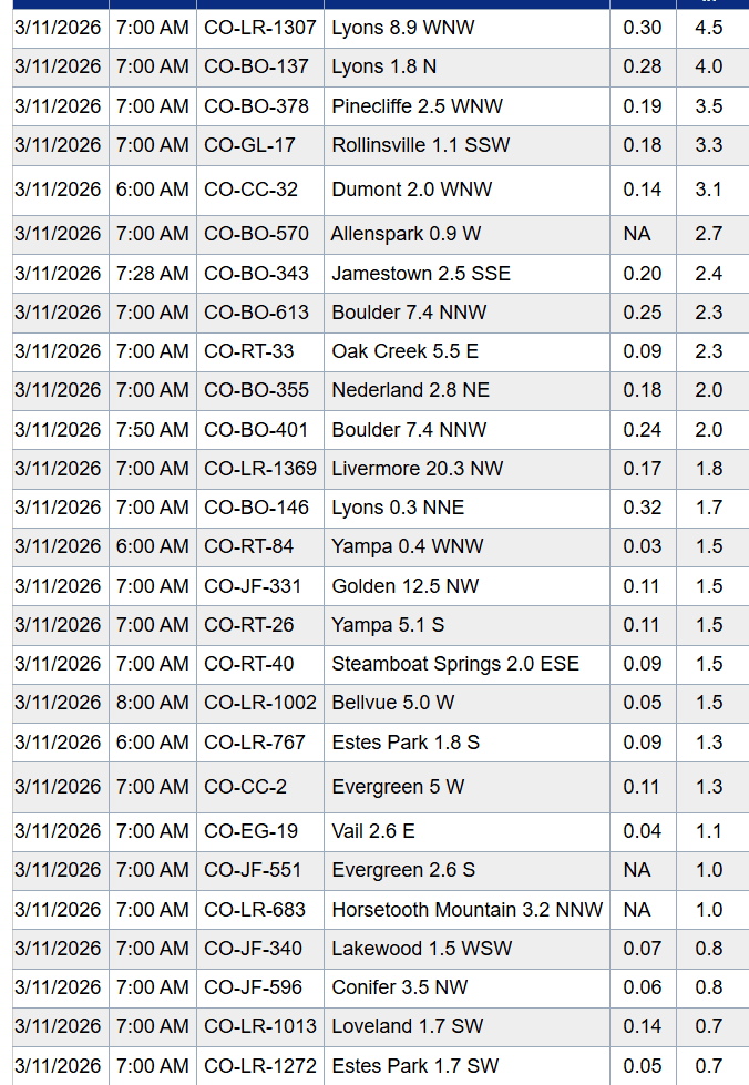
Here are some notable town reports from CoCoRaHS:
Lyons 8.9 WNW: 4.5"
Pinecliffe 2.5 WNW: 3.5"
Rollinsville 1.1 SSW: 3.3"
Dumont 2.0 WNW: 3.1"
Allenspark 0.9 W: 2.7"
Jamestown 2.5 SSE: 2.4"
Nederland 2.8 NE: 2.0"
Estes Park 1.8 S: 1.3"
Evergreen 5 W: 1.3"
Lakewood 1.5 WSW: 0.8"
Loveland 1.7 SW: 0.7"
Snow showers will end in the mountains by 10am this morning. Giving way to sunny skies and some wind.
Windy across much of the mountains and front-range tomorrow, especially just east of the Cont. Divide (Front Range mountains and foothills). I'll have more on that later.
How are conditions in your neck of the woods this morning? How much snow?
First 4 images show either current or early morning snow-stake views for Loveland, Winter Park, Breck (since 5am), Eldora. Image 5 is the view near my house in Westminster this morning. 6th image shows top snow reports from CoCoRaHS this morning.


Like what you read?
Receive daily weather reports straight to your inbox with Seth's Daily Newsletter. Sign up below.