Snow reports from the Wed to Fri storm system
Jan 10, 2026
01/10/26 12pm: Well it turned out to be a pretty good snow-storm after all. Some final snow totals below.
Wasn't nearly as much of a bust as I thought on Thu night...I freaked out a bit based on latest high-res model runs but is a good reminder that during the storm (or within 24hrs) stick with the forecast, ignore the noise from the high-res models.
Overall the ECMWF model did the best in terms of consistency and final amounts (its still the #1 global model). The GFS also did a good job nailing the high totals near Colorado Springs but not great for Denver leading up to the event and at the end on Thu afternoon. The high-res HRRR and CAIC 2km runs from Wed were good, but not from Thu ironically, usually high-res is better closer, but not this time.
When I look at my forecast map from Thu morning (which I'll post in the comments), it panned out pretty nicely. Most areas fell into range except the foothills (that was still a bust).
Turns out the low strengthened just far enough east of Thu night that the heaviest snowfall locally was from Boulder to Golden and east over Denver with much less in the foothills. Great to see a solid 3-8" for Denver/Boulder (similar or less in the foothills). I ended up with 4.8" at my house in Westminster (with 0.29" of swe).
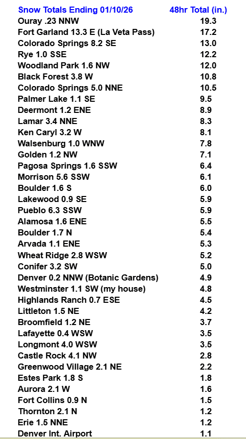
Overall the heaviest snowfall overall was near Colorado Springs and down towards La Veta Pass and parts of extreme southeast CO with 10-15" in those areas . Also amazed to see nearly 20" in Ouray. Models did pretty well with southeast CO on Thu.
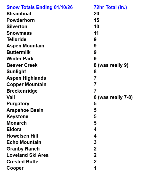
In the mountains, the forecast totals for the ski areas (per my map on Thu morning) actually panned out pretty well with most areas getting into the range. Good to see a solid 5-12" at most of the local ski areas. The one area that really boomed this time around was Steamboat ski areas with 20" in 3 days (so hard to forecast Steamboat ski area accurately).
Anyway, lots of lessons learned with this one...mostly staying the course with a very complex and uncertain forecast. But ultimately so pumped the snowfall came through.
Looking ahead, warm and dry from today through at least Thursday. Then some of the latest model runs (like 12z GFS) show a cold-front moving into CO from the north on Thu night into Fri (01/15-01/16) with some more light snow possible for the mountains (late Thu into mid-day Fri). And maybe even some light snow for Den/Bou on Fri. ECMWF doesn't really show this so it may not happen (uncertainty is high).
So enjoy the warm and dry weather through Thu.
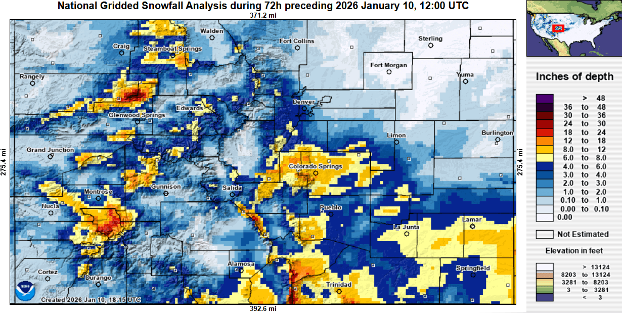
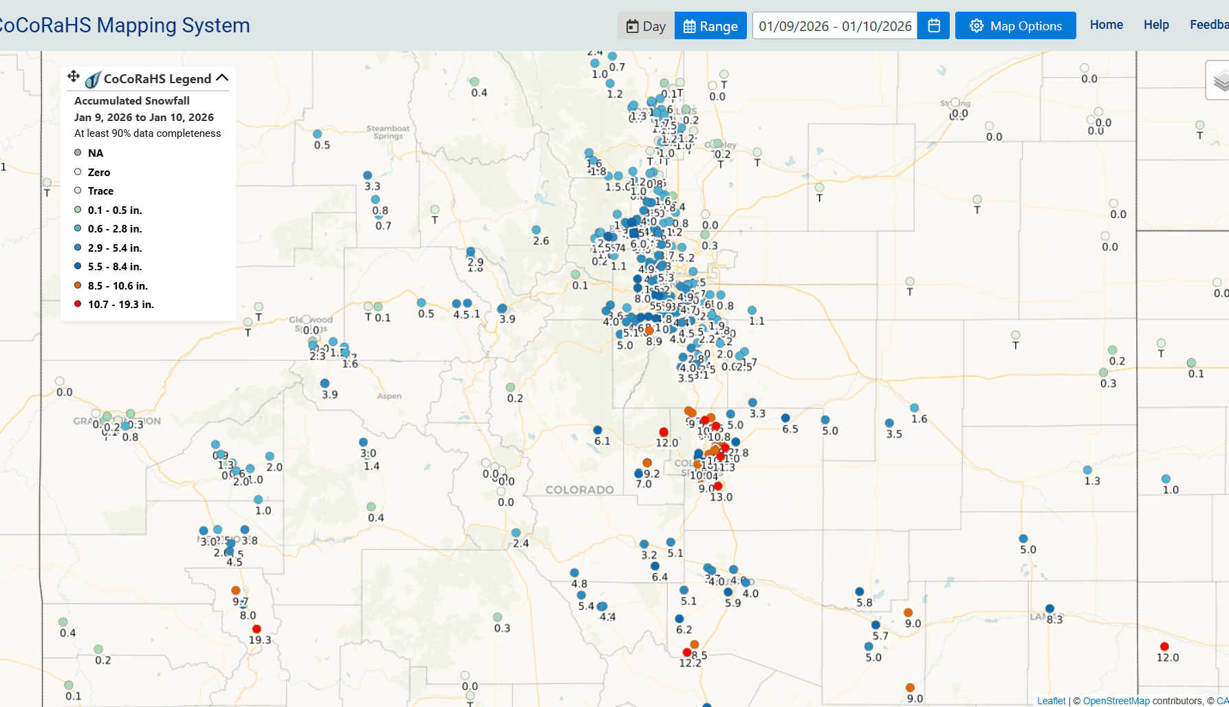
First image shows notable 48hr totals from CoCoRaHS for towns, mostly for the front-range, but also a few mountain towns. Image 2 shows 72hr totals for the ski areas. Image 3 shows observed 72hrs snowfall from NOHRSC (this is interpolated snowfall analysis so it can be off in spots but gives a good general idea of the snow that fell). Fourth image shows a map of 48hr snowfall reports from CoCoRaHS you can see where the heavy totals were.

Like what you read?
Receive daily weather reports straight to your inbox with Seth's Daily Newsletter. Sign up below.