Rain reports from Mon into Tue. Already 1-3" of rain for parts of southwest CO.
Sep 29, 2026
09/29/26 8:15am: Southern CO continue to have all the fun! Wow, already some impressive rainfall reports across southwest CO this morning. Radar estimated precip shows that areas near Wolf Creek Pass picked up >2.50" of rain and areas between Durango, Silverton and Pagosa Springs picked up 1.25-2.25" of rain! Much less for northern CO.
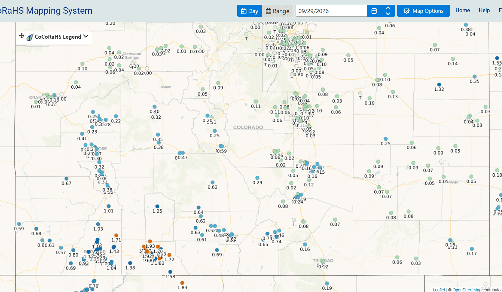
Below I show 24hr observed rainfall from MRMS (image 1) along with top 24hr rain reports from CoCoRaHS (image 2) and a map snippet showing top reports across southern CO (image 3).
Here are some notable top reports from CoCoRaHS:
Pagosa Springs 9.0 NNW: 1.93"
Pagosa Springs 7.6 SE: 1.82"
Bayfield 16.2 N: 1.71"
Durango 2.1 NE: 1.45"
Durango 2.8 S: 1.29"
Creede 3.3 SSW: 1.25"
Hermosa 0.9 ESE: 1.15"
Ignacio 2.9 N: 1.04"
Silverton 0.3 WSW: 1.01"
Fort Garland 7.0 NE: 0.74"
Alamosa 1.2 NE: 0.62"
Salida 2.0 S: 0.59"
Crested Butte 6.2 N: 0.40"
Ouray 2.1 NNW: 0.38"
Montrose 4.5 SSE: 0.30"
Hotchkiss 0.7 NNE: 0.28"
Pueblo 6.3 SSW: 0.16"
Colorado Springs 7.6 NNE: 0.13"
Aurora 2.1 ESE: 0.06"
Anyway latest radar image (image 4) shows heavy rain ongoing over parts of southern CO, especially near La Veta Pass to Trinidad area and also in parts of northern NM.
Soon I'll show some model trends, but as expected, a bit of a shift to the southeast for the Wed/Thu storm (between what the ECMWF was showing and the GFS) and hence a sharp drop-off in precip north of Denver (but that was already baked into my forecast rainfall / snowfall map I posted last night, which still looks good and I'll post in the comments).
How much rain did you get in the last 24hrs?




Like what you read?
Receive daily weather reports straight to your inbox with Seth's Daily Newsletter. Sign up below.
