Rain and snow reports from the Sun/Mon wave, more rain/snow coming through Tue pm
Apr 27, 2026
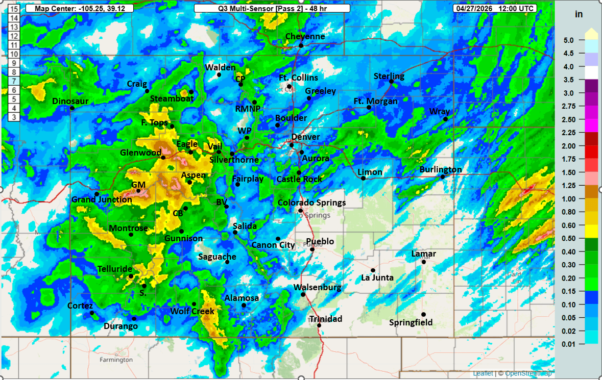
04/27/26 8:30am: Some much needed precip across the state! Great to see some meaningful rain and snow totals across the state this morning and we are only half-way through in terms of totals by Tue morning (with another short-wave moving through today).
As I posted in the weather group (Seth's Weather Group), socked in with heavy fog and drizzle along the northern-front-range (Den/Bou) this morning.
But the big story is the much needed, heavy rain and snow that fell already, especially over western and southwestern CO as expected.
Parts of the San Juans and Elks picked up 10-15" of new snow.
Much of that part of western/southern CO also picked up 0.50" to 1.50" of liquid precip and rainfall at lower elevations.
For the rest of the north-central mountains: 3-8" of new snow so far with more like 0.25" to 0.60" of liquid precip (with more to come).
For Den/Bou a bit more spotty, but more rain on the way today / tonight. Closer to Boulder: 0.10" to 0.25" of rain. Otherwise 0.05" to 0.15" in spots. I measured 0.05" at my house in Westminster.
Here are some notable 48hr snow totals estimated from webcams and also from snotel reports via CAIC:
Coal Bank Pass snotel (eastern San Juans): 14.8”
Senator Beck snotel (western San Juans): 12.2”
Wolf Creek Pass snotel: 11.0”
Telluride Ski snotel: 10”
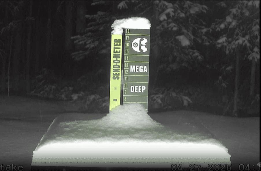
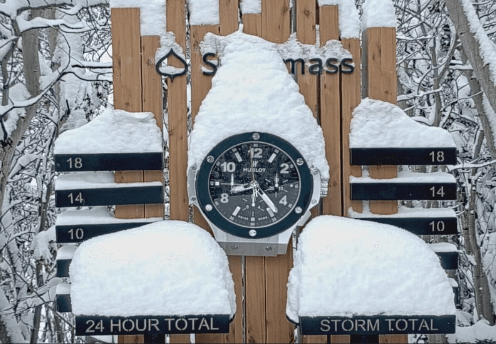
Snowmass: 10”
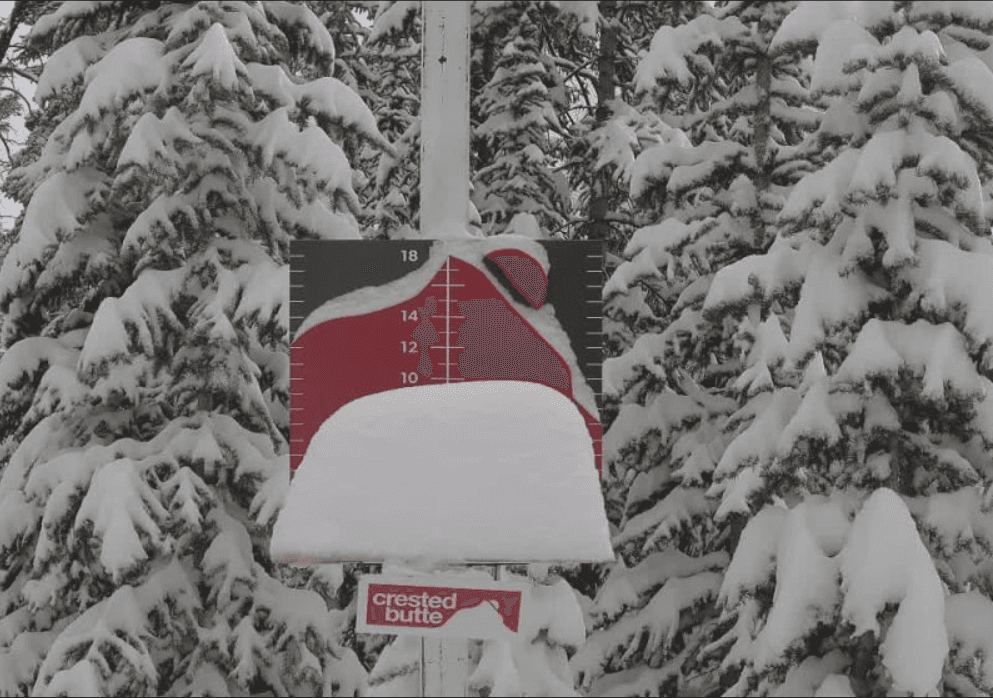
Crested Butte: 10”
Irwin snotel: 9.4”
Vail: 8”
Grand Mesa: 7”
Copper: 6”
Winter Park: 5”
A-Basin: 4”
Loveland: 4”
Berthoud Summit snotel: 4”
Copper: 3”
Here are some top 24hr rain reports from CoCoRaHS this morning:
Crested Butte 6.2 N 1.06
Frederick 1.1 SSW 0.70
Carbondale 5.5 E 0.70
Cedaredge 3.5 N 0.66
Glenwood Springs 2.1 NW 0.65
El Jebel 0.8 W 0.64
Hotchkiss 4.7 W 0.57
Delta 8.8 E 0.56
Glenwood Springs 7.2 S 0.56
Dolores 5.3 SSW 0.52
Ouray 2.1 NNW 0.52
Silverton 0.3 WSW 0.52
Carbondale 0.5 W 0.50
Dinosaur 0.3 SW 0.50
Cedaredge 1.3 E 0.46
Pagosa Springs 8.5 WNW 0.44
Vail 0.9 WNW 0.43
Gypsum 1.0 SW 0.41
Dolores 4.0 SSW 0.39
Montrose 5.4 W 0.38
Delta 5.9 S 0.38
Norwood 0.1 W 0.38
Montrose 3.2 WSW 0.35
Boulder 4.7 E 0.34
Parachute 0.4 NNW 0.33
Steamboat Springs 0.9 SSW 0.33
Palisade 3.3 ENE 0.32
Grand Junction 4.1 ENE 0.31
Gunnison 6.6 N 0.29
Montrose 0.5 NE 0.29
Rifle 3.2 ENE 0.28
Castle Rock 0.8 WNW 0.25
Lafayette 2.5 NW 0.25
Creede 3.3 SSW 0.25
The Pinery 1.2 ESE 0.24
Evergreen 2.7 SSW 0.24
Longmont 5.1 E 0.22
Edwards 1.3 WNW 0.22
Sedalia 6.8 S 0.22
More rain and snow on the way as a second short-wave moves through.
Den/Bou will have a good chance for scattered thunderstorms and rain showers today between 1pm-10pm today with some heavier rain in spots. Turning wet this afternoon / evening (already is wet out there lol).
The mountains can expect on/off round of snow (above 9kft) from now through 6pm Tue (heaviest Mon night into Tue am, also Tue afternoon into early Wed): Local ski areas may pick up an additional 3-8" of new snow favoring areas near the Cont. Divide.
I'll have more on the forecast later.
First image shows 48hr observed liquid precip from MRMS. Images 2-4 are near current or morning snow-stake views for Crested Butte, Snowmass and Copper Mtn.
How are conditions in your neck of the woods this morning?

Like what you read?
Receive daily weather reports straight to your inbox with Seth's Daily Newsletter. Sign up below.