Quick look at possible snow-totals from two storm systems through Mon morning
Nov 26, 2025
11/26/25 1:30pm: One thing that is becoming a bit more clear is that the north-central mountains will get a good amount of snow (> 10" in spots) from the two storm systems combined: The Fri/Sat storm and the Sun/Mon storm system (two distinct waves, back to back).
Not as clear for the front-range Den/Bou, but likely some light snow early Sat am and more light snow Sun afternoon into Mon am and turning much much colder.
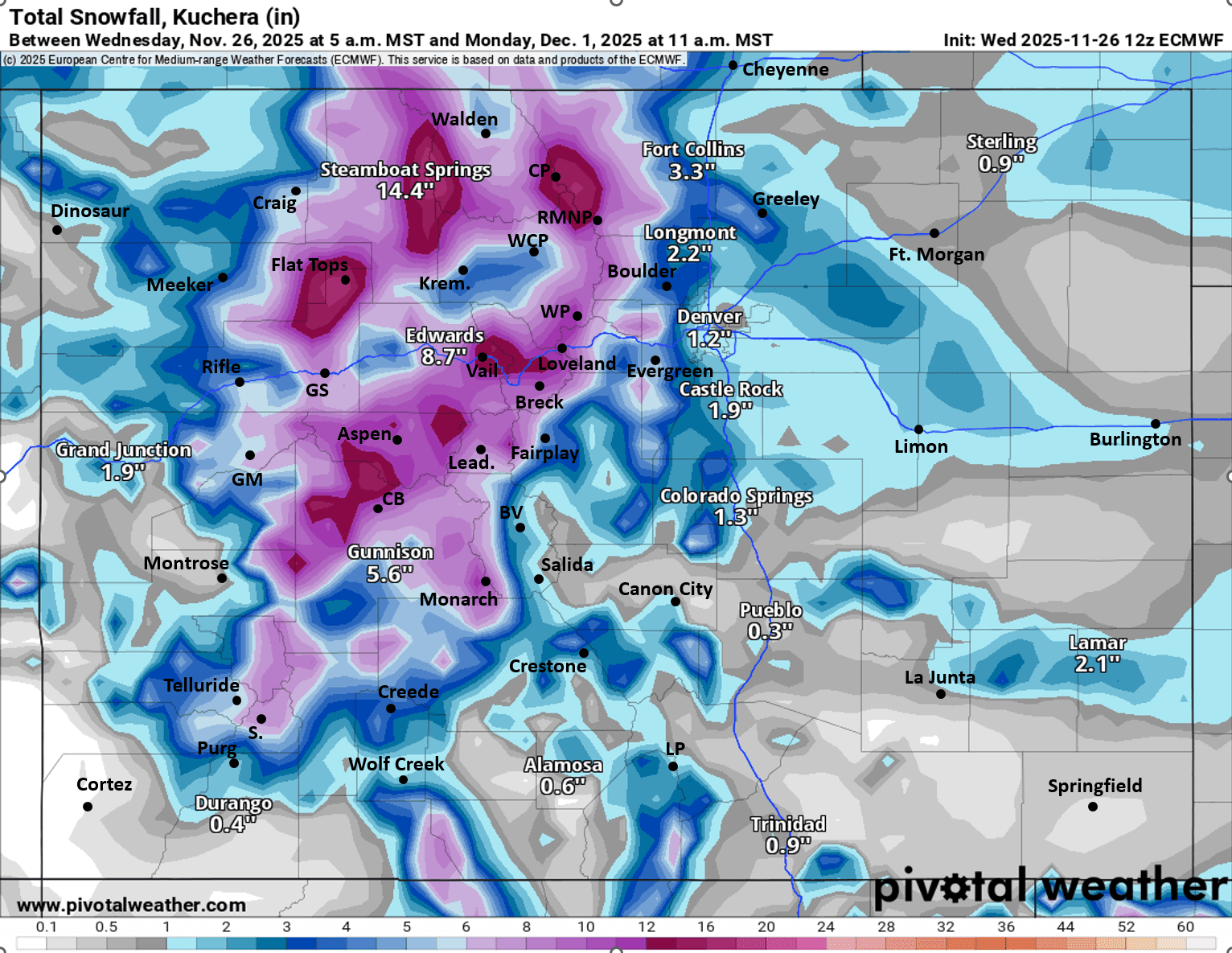
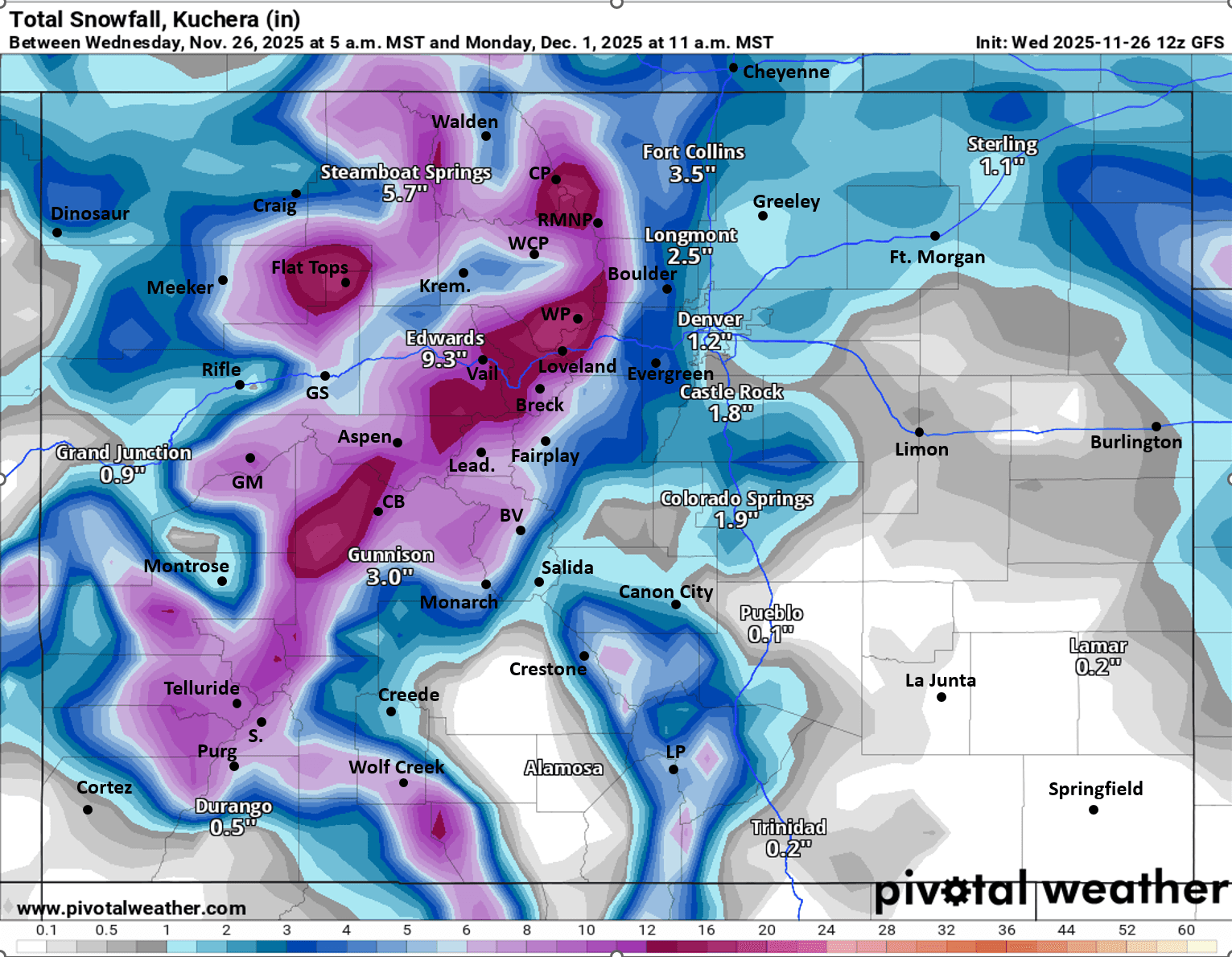
I'm basing my forecast off a combination of the latest (12z: 5am initialized) ECMWF and GFS models. ECMWF shows a stronger first wave (Fri into Sat) but a weaker second wave (Sun into Mon). GFS on the other hand has a weaker first wave and stronger second wave, so devil in the details.
General timing
First storm system expected from 8pm Fri to 11am Sat, biggest impacts early Sat morning
Second storm system from: 11am Sun to 5am Mon, biggest impacts on Sun night
Here are some general snow totals I'm seeing from both waves combined:
North-central mountains including Steamboat, Aspen, Vail, Copper, Breck, A-Basin, Loveland, Winter Park, IPW, RMNP, Cameron Pass, etc: 8-16" of new snow by Mon am (heaviest snow in areas favored by northwest flow)
Mountain towns / valleys: 2-8"
South-central / southwest mountains (Crested Butte, Grand Mesa, Monarch, Telluride, Silverton, Purgatory, Wolf Creek, Sangres, etc): 6-12"
Northern front-range including Denver, Boulder, Ft. Collins, Castle Rock: 1-4" total (some Sat am, some Sun night)
Northern Foothills including Estes Park, Allenspark, Nederland, Evergreen, Conifer, etc: 3-7"
Southern front-range including Colorado Springs, Pueblo, Trinidad ect): 1/2" to 3"
Southern foothills (Woodland Park, areas near Pikes Peak, areas west of Canon City, Wet Mountains, etc): 1-4"
Details will change some so stay tuned. Fingers crossed for good snowfall.
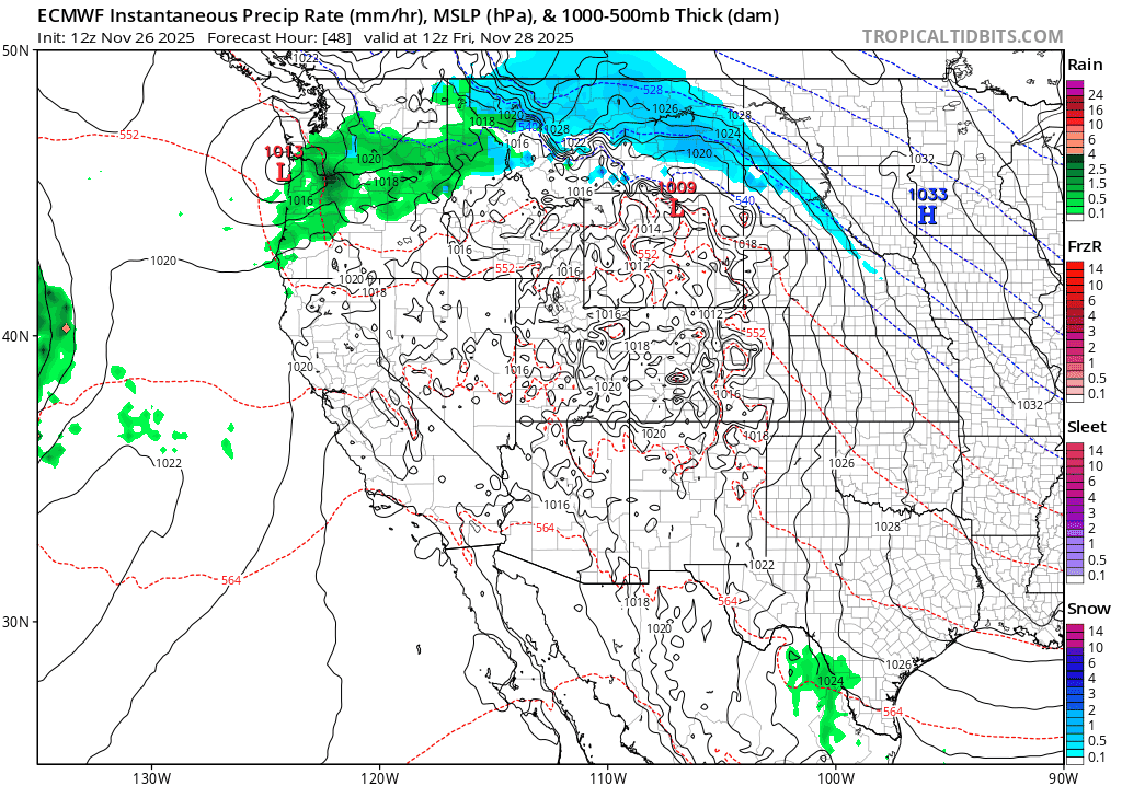
First image shows forecast precip-type/rate and thickness from Fri morning through Tue morning. Image 2 and 3 compare forecast total snowfall from now through 11am Mon from very latest ECMWF and GFS, take modeled snow amounts with a grain of salt.
I'll be working on an initial snowfall map for the Fri/Sat storm tomorrow.

Like what you read?
Receive daily weather reports straight to your inbox with Seth's Daily Newsletter. Sign up below.