Preliminary snowfall forecast map for the Fri to Sun storm (from my post last night on 01/21)
Jan 22, 2026
01/21/26 7:30pm: Good evening. Below is my preliminary snowfall map for the approaching storm system. Forecast remains on track and most of the models are in fairly good agreement, although devil is always in the details and some of it could change. But below is my best guess based on a combination of models in my head.
Most of the impacts will be from 8am Fri to 8pm Sun (this includes the second wave on Sun am).
Just a few changes: Most of the snow for Den/Bou and the northern front-range will really be from 5pm Fri through 5pm Sat with just a little bit of light snow / flurries on Fri during the day when the really cold air comes in.
Still looks very cold for the front-range on Fri and especially Sat. On Fri temps falling to 10-15 degs by Fri afternoon. On Saturday, high temps may not get above 10 degs (for Den/Bou and the plains). For the Broncos game: expect temps in the low 20s but partly cloudy (chilly for sure)
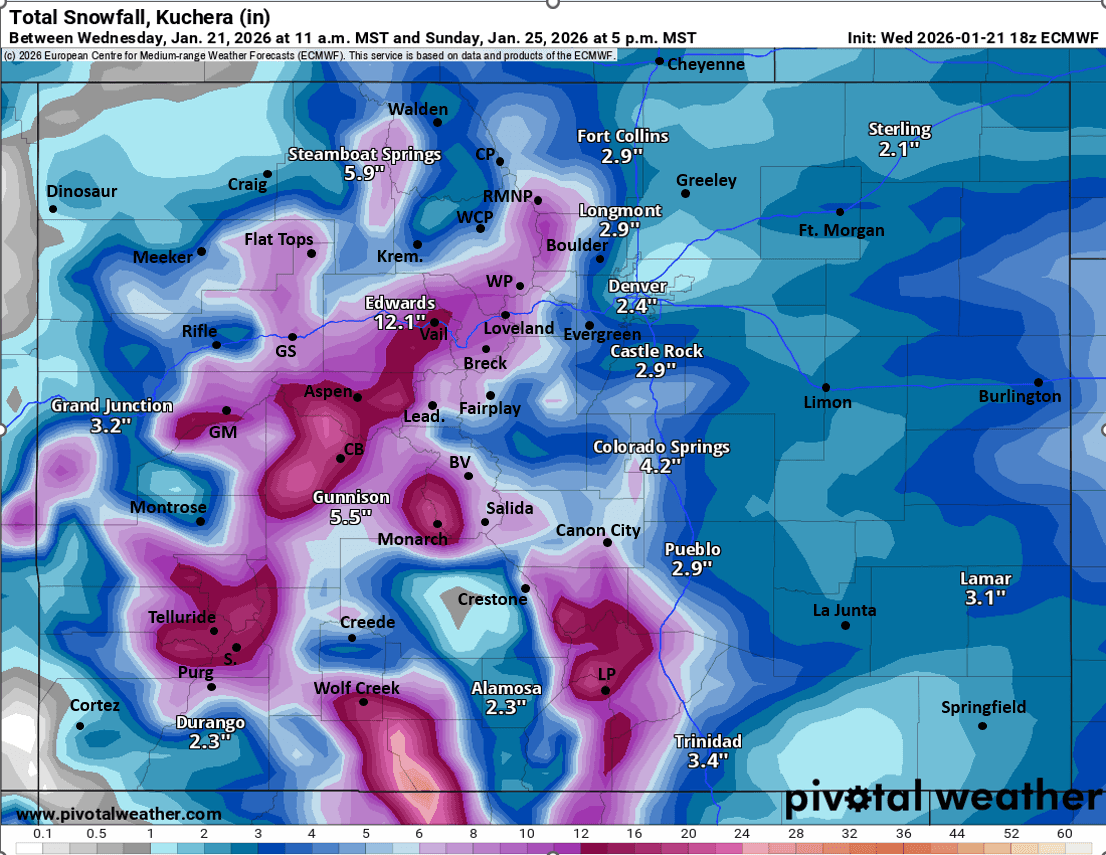
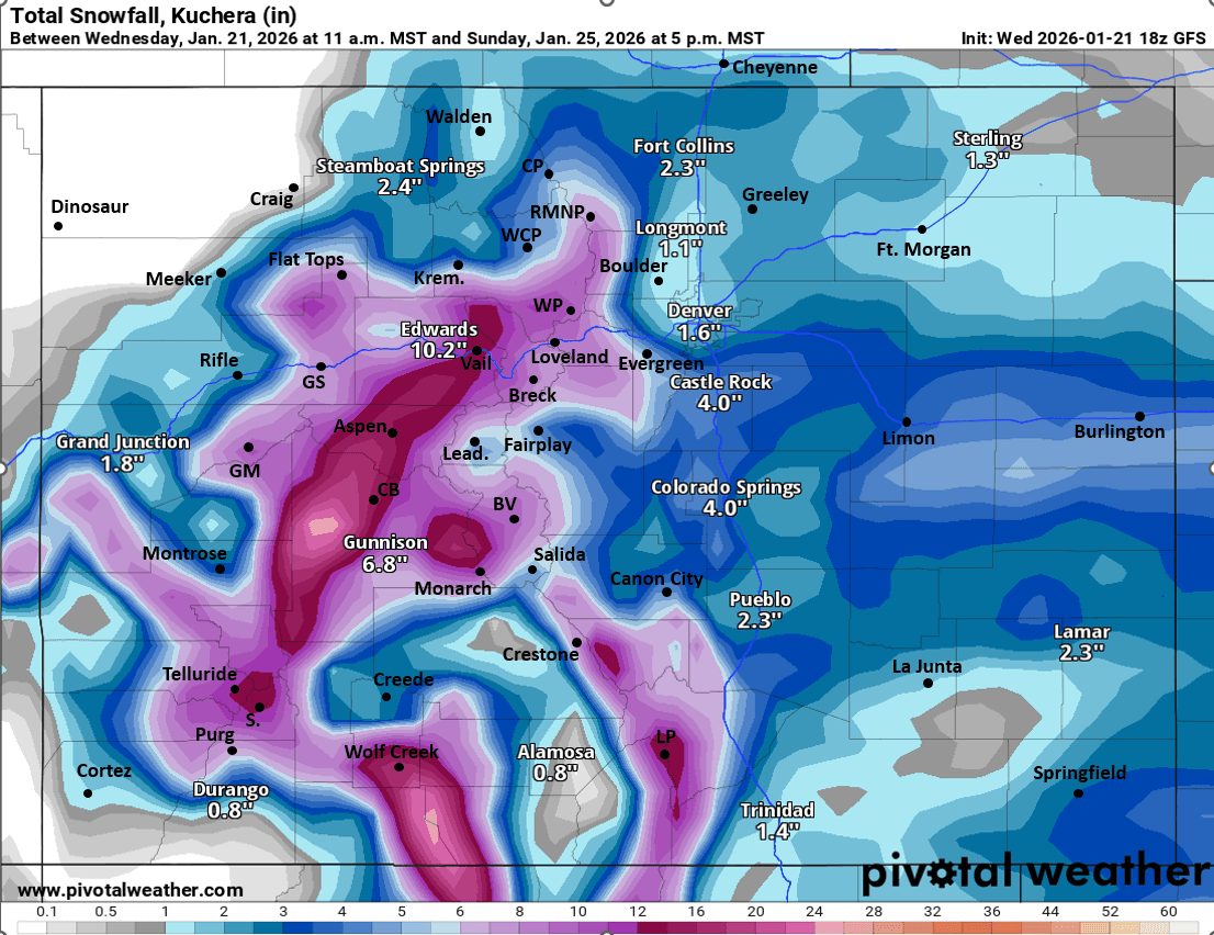
Still looking at generally 2-5" for Den/Bou and the lower elevations with highest amounts expected west of I-25 (areas closer to Ft. Collins maybe favored initially, further south later). Foothills can expect 4-10". Higher amounts on the front-range maybe closer to Colorado Springs and Pueblo (3-6" for those areas). Refer to map
For the mountains: Snow moves in the San Juans by 2am Fri. Snow moves into parts of the western, north-central mountains by 8am Fri, spreading to all areas after 2pm Fri.
Most of the heavy snowfall for the mountains will be from 5pm Fri through 8pm Sat.... Models show a second, kicker wave bringing more snow to the north-central mountains from 2am-2pm Sun, so there could be a break between this and the main storm system ( a break Sat evening) but more snow Sun am. My map below does include the Sun snow with totals through 8pm Sun.
Still looking at general totals for the local ski areas in the 6-14" range with highest amounts west of Vail Pass.
Overall highest snow amounts expected in the western / southern Elks, near Crested Butte and west / southwest. Also in parts of the San Juans, generally 10-20" for those areas, refer to map.
Also going to be very cold in the mountains on Saturday with high temps only in the single digits to low teens. Will remain cold on Sun morning with more snow falling.
The pow should be great on Sat and Sun, some cold-smoke for sure.
In terms of wind, overall not that windy with this event at least through Sun am Then stronger wind over the Front Range mountains as the storm exists the state, strongest along/east of the Cont. Divide on Sun: 10am-6pm: westerly wind-gusts of 30-60 mph, less wind further west.
That is all for now. Looking forward to our coldest temps of the season, some real winter weather lol! And of course some deep pow in the mountains (should be pretty blower) 🙂
May have to make a few adjustments to my map tomorrow.
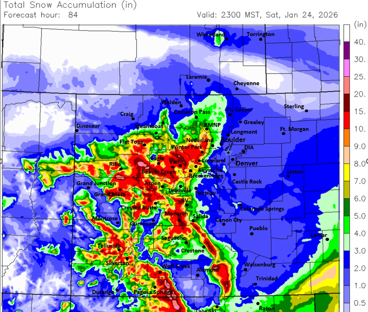
First image is my preliminary snowfall forecast from Fri morning through 8pm Sun (when the second wave ends). Images 2 and 3 compare forecast total snowfall from now through 5pm Sun from very latest ECMWF and GFS models. Fourth image shows forecast total snowfall through late Sat pm from latest high-res, CAIC WRF 2km model....take modeled snow amounts with a grain of salt (refer to my map for expected amounts).

Like what you read?
Receive daily weather reports straight to your inbox with Seth's Daily Newsletter. Sign up below.