Potentially a more significant storm brewing for Mon pm through Wed pm. Snow for Den/Bou?
May 2, 2026
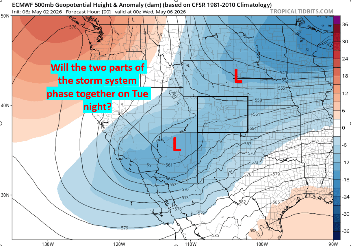
05/02/26 10am: Hi, happy Saturday! As I mentioned last night we have a potentially significant storm system brewing for Mon afternoon through Wed afternoon but it will all depend on how the separate storm systems (an upper-level low from the southwest and a cold trough from the north) phase together over CO.
If they stay more separate (like the southern low stays south, the northern branch stays more north), then less impacts, especially for Den/Bou. But if they come together it could be a good precip event with snow in Den/Bou Tue night.
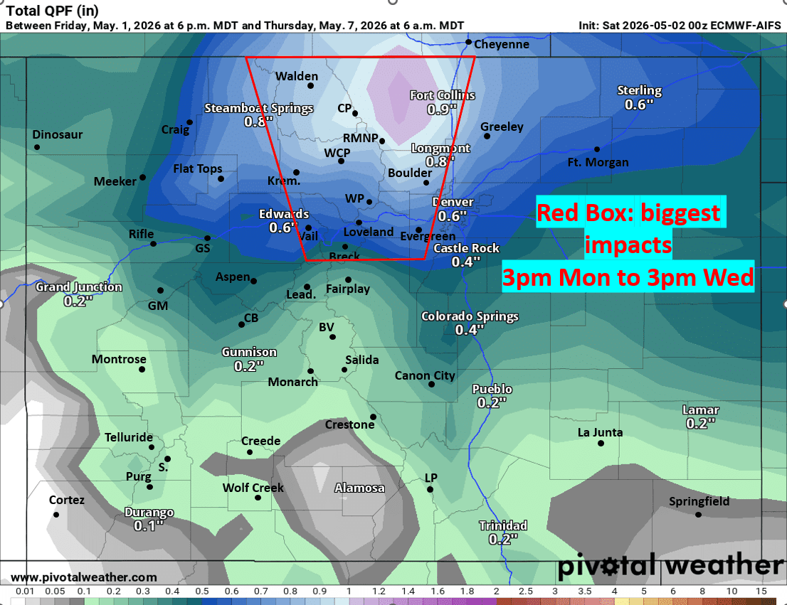
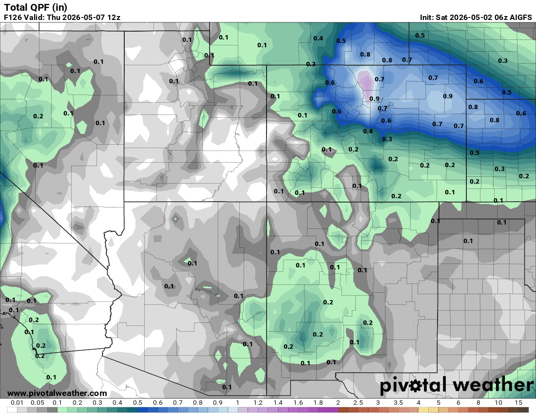
The first image shows the setup with the big question mark. Also since we are still 2-3 days out, it's informative to look at the A.I. models to see where the best chances are for heavier rain/snow. For the A.I. models we don’t focus on exact amounts, but just look to see where the “consensus is”, I highlight this in the second image below.
Here is what I’m seeing right now, of course some of these details will change:
Snow / snow showers move back into the north-central mountains by 8am Mon with some minor accumulation during the day Mon (mostly above 9k ft, near the Cont. Divide).
The main impacts for the mountains and front-range will be 3pm Mon through 3pm Wed with heaviest rain/snow on Tue night into early Wed am.
For Den/Bou and the northern front-range some rain showers and weak thunderstorms possible Mon afternoon 3pm-9pm. On Mon night the rain/snow will likely be mostly north of Den, closer to the WY border (Ft. Collins to Cheyenne will be favored initially)
More consistent rain/snow develops in Den/Bou and the front-range by 6am Tue, rain/snow mix initially (snow in the foothills).
Then rain may change to all snow in Denver by Tue night into Wed and it could start to accumulate in spots. To early to get into exact amount (but maybe 1-4”+ for lower elevations)
Foothills likely have some significant accumulating snow on Tue into Wed, possible 4-8”+ in spots by Wed, high uncertainty.
For the mountains, this will be another event where the Front Range Mountains (along/east of the Cont. Divide) will be favored, since its another upslope event. But even for areas near Summit, ClearCreek and Grand counties east should do well for snowfall.
Most of it from Mon night through Wed am: could be 6-12” for the higher terrain (favoring ares near/east of the Cont. Divide: Loveland, Berthoud, WP, IPW, RMNP, Cameron etc). Details still need to be worked out.
Generally much less impacts west of Summit Co as this is a true upslope event. So likely not much for western CO.
Does look like the San Juans will get some decent snowfall (from the southern track low) on Tue into Wed as well.
Also southeast CO will likely get some rain / snow as well (Colorado Springs to Publo and east) Tue into Wed but highest impacts will likely be from the Palmer Divide north.
First image shows the setup at 6pm Tue (we want these to come together over CO). Image two shows where I think the biggest impacts will be via the ECMWF-AI model (AIFS) and third image compares that to a regional view of the GFS-AI model (AIGFS), you get the picture....

Like what you read?
Receive daily weather reports straight to your inbox with Seth's Daily Newsletter. Sign up below.