Forecast for the weekend and next week: hot, cool, wet at times, then hot again
Jul 31, 2026
07/31/26 9:25am: Happy Friday. Can you believe its the last day of July (only 1 more month of meteorological summer). Anyway, lets take a look at what we can expect for the weekend and beyond: we will stick with the pattern of very hot weather followed by surges of monsoon moisture / cool-fronts at times: overall warm and wet at times as expected with a strong El Nino developing. Here are some main points (and these are reflected in the graphics below):
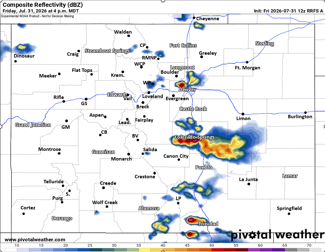
- For today (Fri) a chance for some isolated to scattered thunderstorms for both the Front Range mountains, foothills and urban corridor (Den/Bou) between 2pm-8pm. Best chances initially closer to Colorado Springs. For Den/Bou best chances around 4-6pm, maybe a few stronger storms in spots. Most of the action will be east of the Cont. Divide today.
- Turning hot and dry for the weekend: especially hot on Sun and Mon with temps near/above 100 for Den/Bou and the front-range lower elevations again
- Mostly dry in the mountains this weekend (maybe a few isolated storms near the Cont. Divide on both Sat and Sun after 2pm each day, not much)
- Models show a cold-front and some moisture moving into eastern CO and the front-range from the north next Tue/Wed (08/04-08/05) and that will bring better rain/thunderstorm chances each afternoon and cooler temps (those days). Looks like best thunderstorm coverage will be east of the Cont. Divide next Tue/Wed.
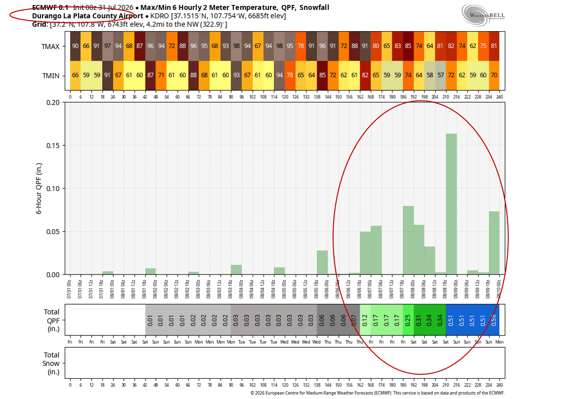
- Then turning hot again for the following weekend (08/08-08/09)...Models show another surge of monsoon moisture initially coming into CO around that next Fri/Sat (08/07-08/10) with better rain chances for the mountains (and maybe front-range). But looks hot again for Den/Bou with temps near 100 (for that end of next weekend: 08/10).
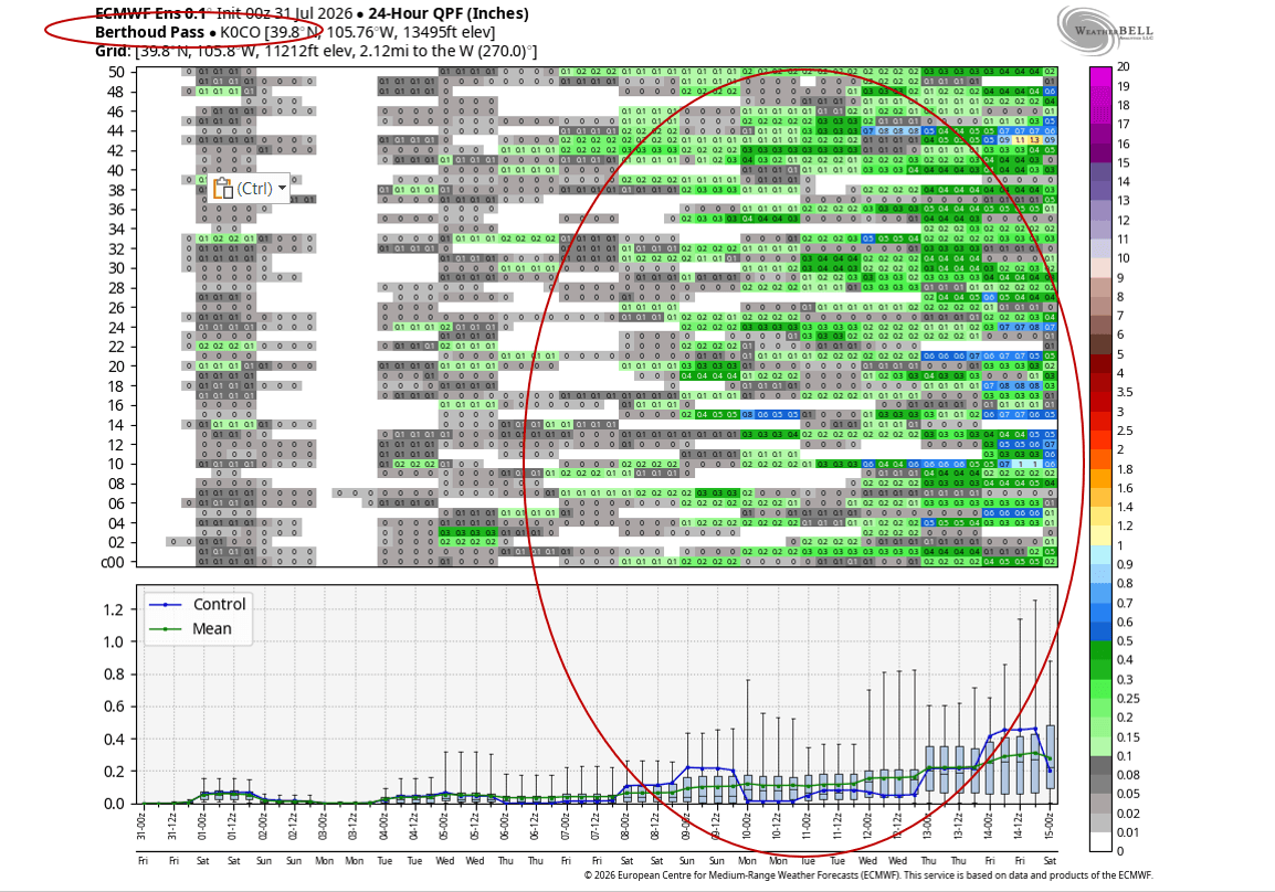
- Looking a ways out, I'm seeing signs of even deeper more consistent monsoon moisture again around 08/11 to 08/15... so the middle of August could be quite active with numerous thunderstorms, favoring the mountains, but its a ways out.
That is all for now. Later today we will look at July total precip across the state.
First graphic highlights the weather using the meteogram for Boullder, CO showing expected high/low temps and I circled the the time-periods that I mentioned. Second image shows forecast radar at 5pm today from latest RRFS model (showing a few storms). Third image is a meteogram plot that shows temps and rain chances / 24hr precip for Durango and you can see it increases after 08/07 with the next monsoon surge. And third image is similar but for Berthoud Pass (ECMWF ensemble plot) showing much better rain chances as we move towards mid-Aug.


Like what you read?
Receive daily weather reports straight to your inbox with Seth's Daily Newsletter. Sign up below.
