Forecast for the week of 11/02 to 11/09. Some snow for the mountains Thu-Sat
Nov 2, 2025
11/02/25 10am, I mean 9am lol! Welcome to Standard Time. I hope you enjoyed the extra hour of sleep...I needed it after that disastrous Buffs game last night lol, at least game 7 of the World Series was exciting. Anyway, already so warm out there today: currently 70 degs at my house at 9am in the morning. Near record highs expected for Den/Bou today with high temps in the upper 70s (50s and 60s for the mountains).
Thought it would be a good time to look ahead at the weather and to see if we have any snow coming to the mountains and front-range. The weather pattern will get a bit more active for the mountains from Thursday to Saturday but it doesn't look significant and the details still need to be worked out.
Models show a short-wave moving across northern CO on northwest flow Thu into Fri and maybe a secondary wave Fri into Sat but that is more unclear. The pattern initially will favor the north-central mountains, especially closer to Steamboat.
For Den/Bou and the front-range I don't see any meaningful chances for snow (or any precip for that matter) for the next 7-10 days. The Thu-Fri storm looks like just a wind producer for the front-range (welcome to La Nina fall lol).
For the north-central mountains including Routt, Eagle, Summit, Grand, ClearCreek, Gilpin, western Boulder/Larimer counties
Warm temps and sunny skies from today through Wed
Snow / snow showers likely from 11am Thu to 2am Fri: 1-4" favoring Park Range (near Steamboat) and Medicine Bow Range (near Cameron Pass)
It will be turning winy across the mountains on Thu into Fri.
Then possible a little bit more snow (or snow-showers) from 11pm Fri through 11am Sat (according to GFS), or maybe not much with all the action north of CO for that second wave (ECMWF)
Then maybe a stronger / colder storm system around 11/11-11/12 (that following Tue/Wed)
Then looks like the pattern could get more active with a more significant storm around 11/14-11/16, but uncertainty is high
For Den/Bou and the front-range
Near record high temps today (highs near 78)
A cool down tomorrow with another little weak backdoor cold-front (highs near 58)
Then back to warm weather from Tue-Thu with highs in the 60s
Then turning windy on Thu afternoon into Fri as the short-wave moves through (with downsloping winds)
Then cooler and windier likely on Fri and Sat but it will remain sunny with temps in the 40s to 50s
Best chances for snow in Den/Bou may be around 11/14-11/16 but uncertainty is high
That is all for now. Enjoy the nice weather while it last. Generally seeing a more active an colder pattern for Colorado for the later part of November, we shall see.
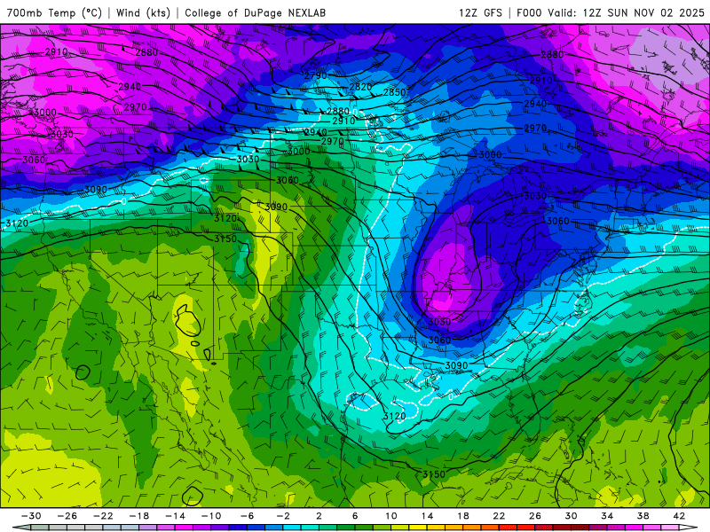
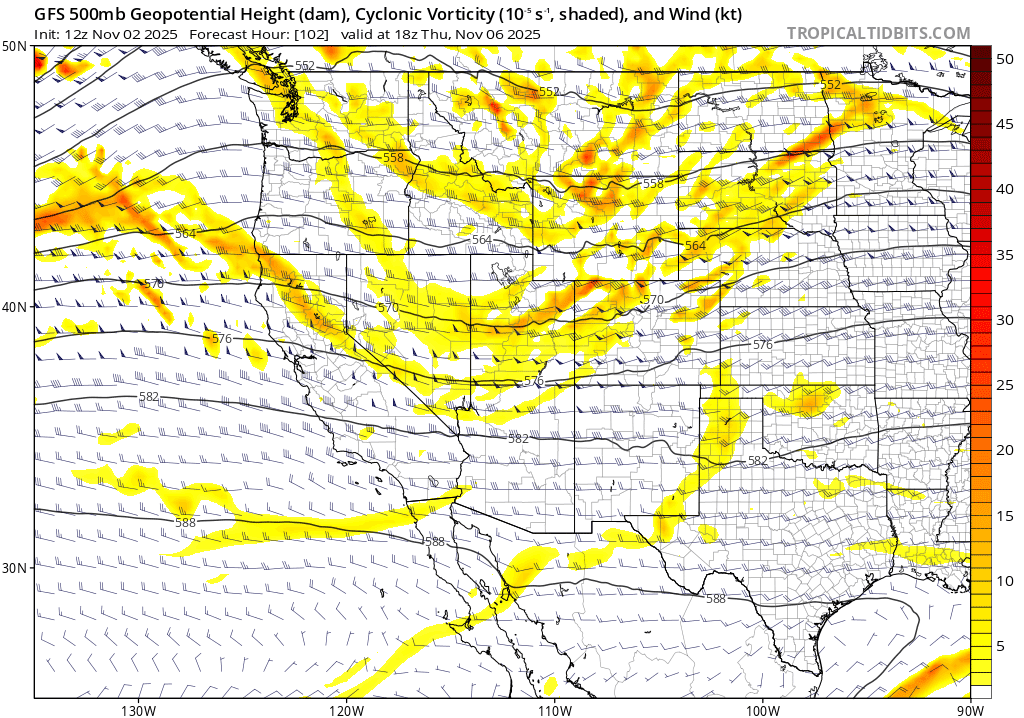
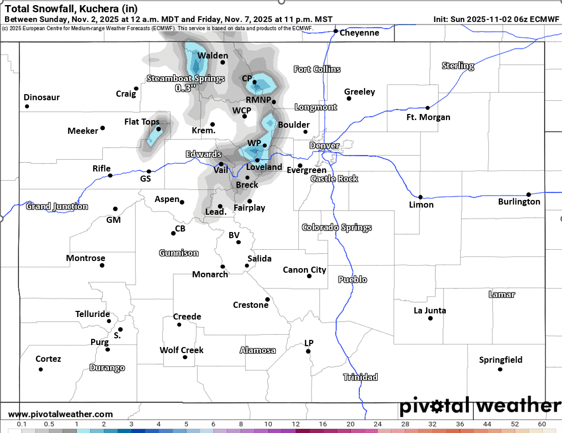
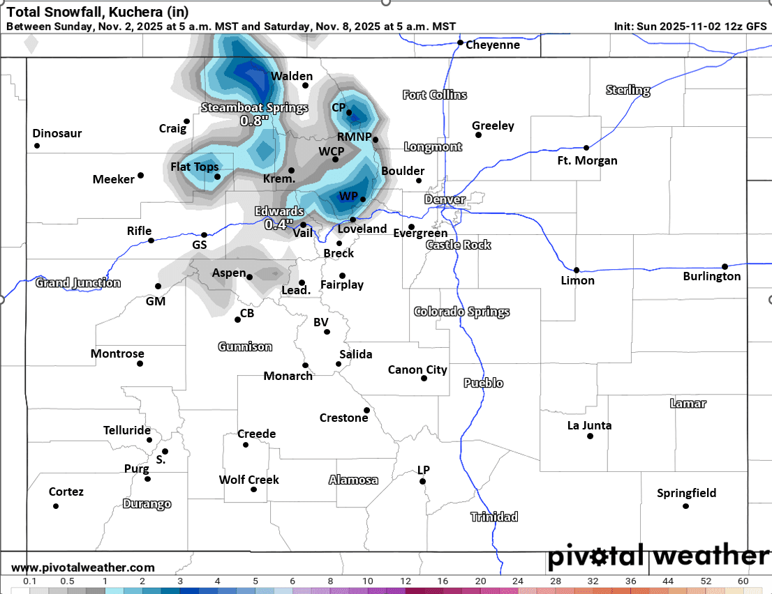
First image loop shows the evolution of the weather pattern over the next 7 days via forecast 700mb temps/winds from latest GFS (we want those blue to purples for the cold-air and storms). Second image shows the short-wave through moving into northern CO at 11am Thu via 500mb vorticity / wind. Images 3 and 4 compare forecast total snowfall from latest ECMWF (through 11pm Fri) and from latest GFS (through 5am Sat), take amounts with grain of salt as the uncertainty is high and details will change as we get closer.
Go Broncos!!

Like what you read?
Receive daily weather reports straight to your inbox with Seth's Daily Newsletter. Sign up below.