Forecast for the week and beyond (08/17-08/26)
Aug 17, 2026
08/17/26 4:20pm: Hi, hope you are having a good Monday. Earlier I was spending some last bit of quality time with my kids as they start school on Wed (can't believe its that time of year). So a bit late, but here is my forecast outlook for this week and beyond. Back to a more normal summer-like pattern: hot at times, some cool-fronts a few days and better moisture at times, especially next week.
Here are some main points:
- Generally increasing thunderstorm chances across the mountains from Wed into the weekend and next week, with best chances likely coming Sat, Sun, Mon, Tue and Wed of next week (next monsoon surge: 08/22 to 08/26).
- Initially for this week: Better thunderstorm chances for the front-range on Tue and especially Wed afternoon behind a cold-front.
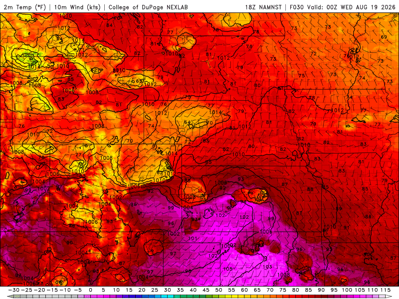
- A cold front moves down the front-range / over eastern CO around 3-4pm tomorrow, this may enhance thunderstorms some (but capping and dry air aloft may be an issue, models show scattered coverage).
- For Den/Bou and the front-range, a chance for isolated to scattered thunderstorms from 2pm-10pm Tue, best chances likely after 6pm (behind the cold-front).
- Northern mountains will have a few isolated storms on Tue afternoon 2pm-8pm, mostly north of Summit CO
- Likely a better chance for storms on Wed pm for parts of the state, with some better moisture and upslope (east to west flow) in place. Southeast CO will be favored for strongest storms on Wed pm, but also parts of the mountains.
- For Den/Bou and the front-range on Wed: isolated to scattered storms from 2pm-10pm (again best chances after 5pm on Wed).
- For the mountains, best coverage on Wed will be generally along/south of I-70 and favoring parts of southern CO (San Juans to Collegiates, SLV to Sangres and Southeast CO): 12pm-9pm (best chances after 3pm)
- More isolated storms over the north-central and south-central mountains on both Thu and Fri from 2pm-10pm each day, favoring areas along/east of the Cont. Divide (north and south).
- Then a better chance for some stronger storms, especially in the mountains on Saturday: generally 1pm-9pm. Much more limited activity for the front-range (Den/Bou) on Sat but maybe some isolated storms after 3pm Sat.
- We will stick with good afternoon thunderstorm chances, favoring the mountains Sun, Mon, Tue, and likely Wed generally 1pm-9pm each day, could be some heavier rain in spots. (08/22-08/26)
- But Den/Bou and the front-range should have decent thunderstorm chances as well on Sun-Wed next week along with some cooler temps (with more cloud-cover). Details need to be worked out tough in terms of rain potential.
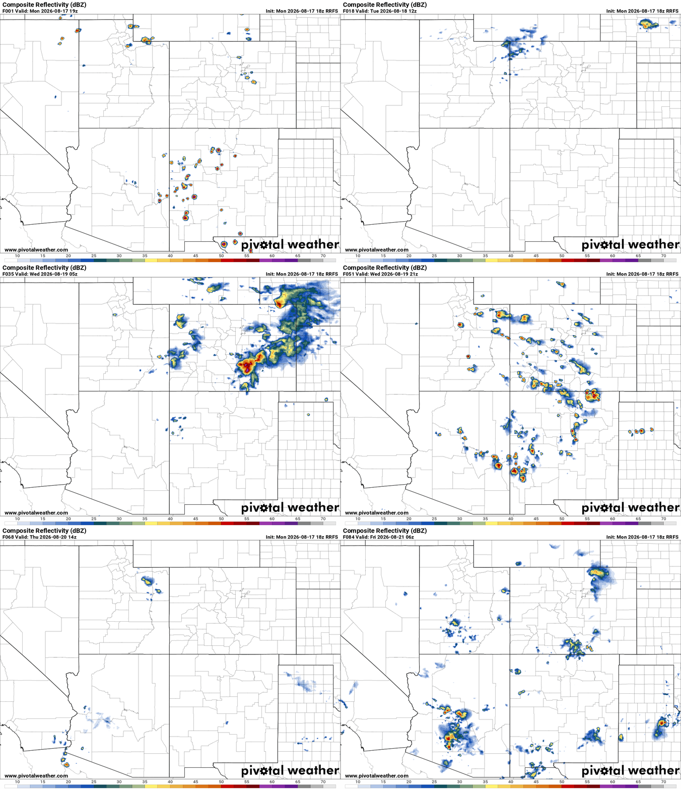
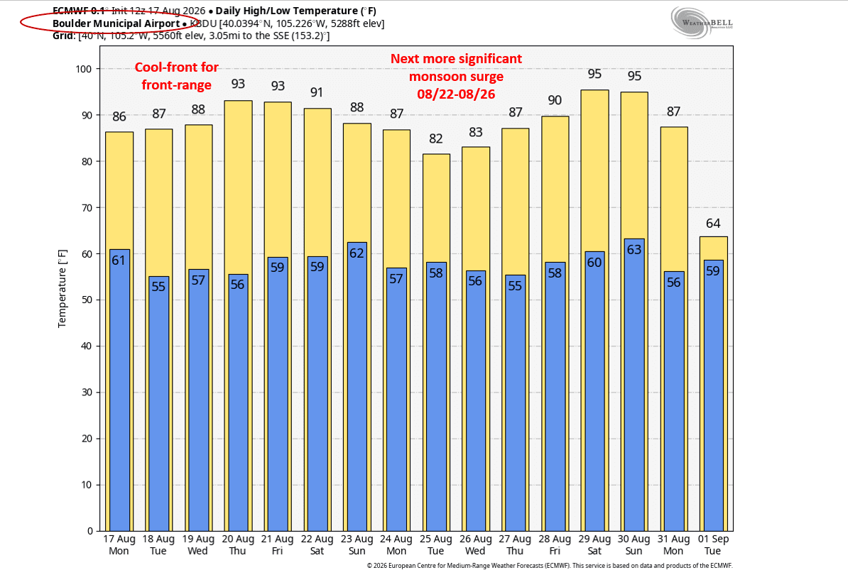
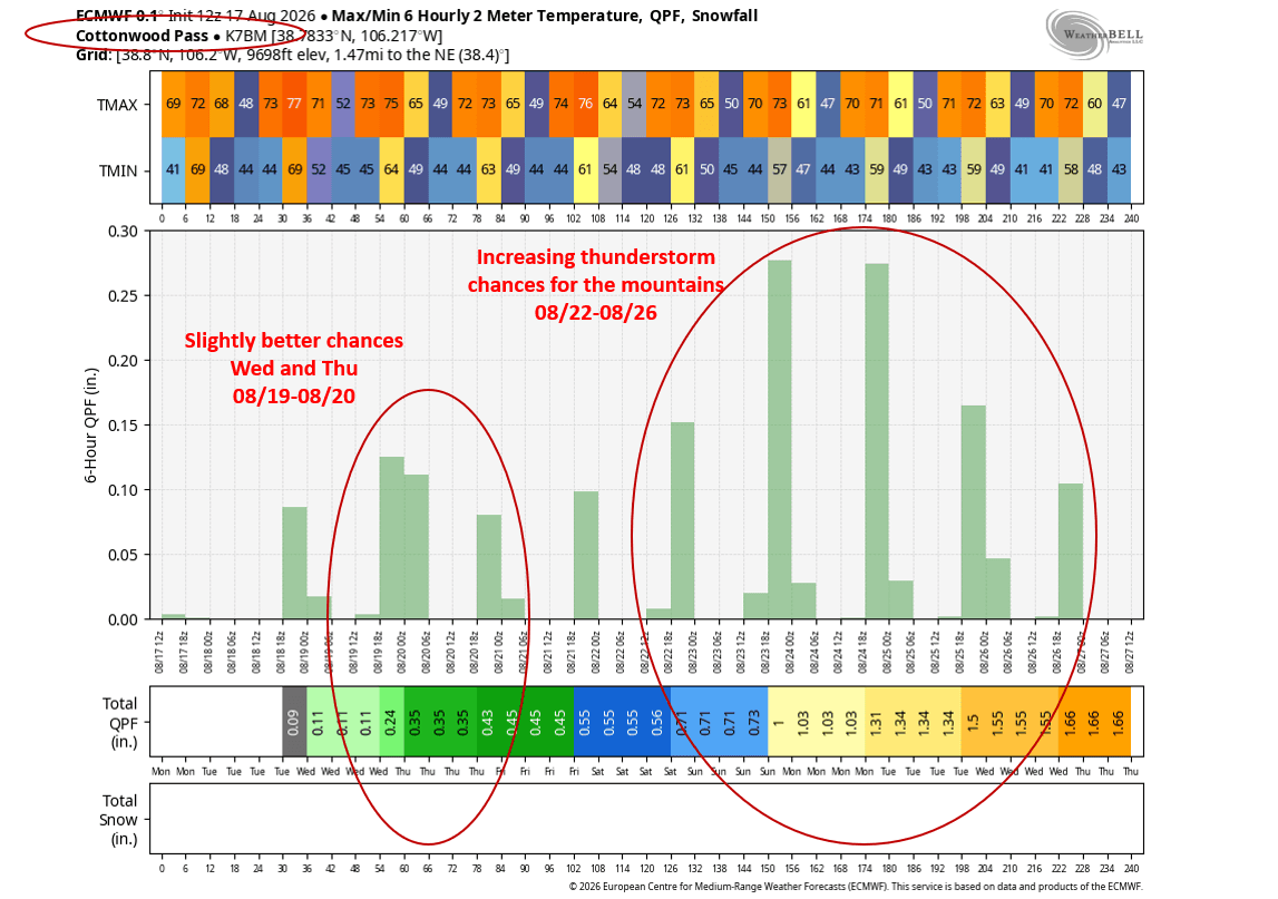
First image loop shows forecast radar over the next 84hrs from latest RRFS model (from 12pm today to 12am Fri), take with a grain of salt but shows general coverage and timing of thunderstorms. Second image shows the cold-front moving down the front-range at 6pm tomorrow from latest NAM model. Image 3 shows the 10-day temperature (max/min) forecast for Boulder and I highlighted the next monsoon surge. Image 4 shows forecast max/min 6hr temps along with 6hr qpf (rainfall) over the next 10 days for Cottonwood Pass (Collegiates) representing the forecast for the mountains and I highlighted the better storm chances.

Like what you read?
Receive daily weather reports straight to your inbox with Seth's Daily Newsletter. Sign up below.
