Forecast details for the weekend: decent thunderstorm chances and hot, cooler by Mon
Sep 4, 2026
9/04/26 9am Happy Friday. We do have a bit of weather to talk about. Hot with a chance for storms today and tomorrow, mostly east of the Cont. Divide and for parts of the front-range foothills and mountains. A better chance tomorrow in similar areas. But still nothing too major. A deeper monsoon surge for Mon, combined with a cool-front and upslope for the front-range.
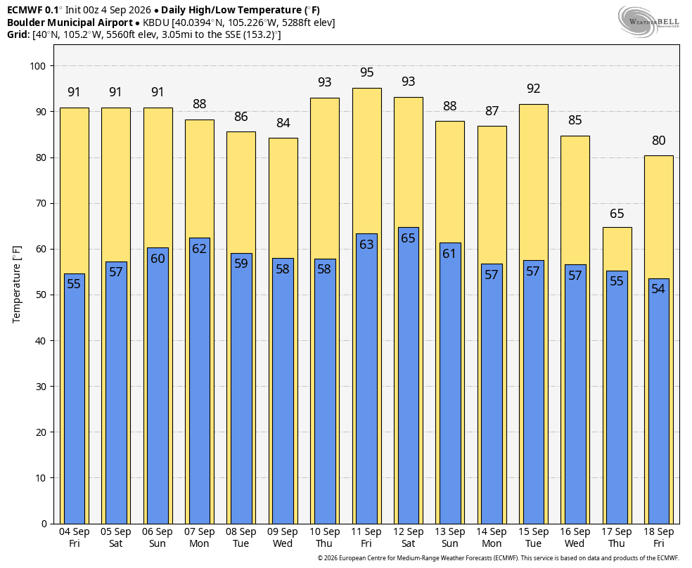
First hot today and tomorrow, especially for Den/Bou with highs in the mid-90s sigh (so over this heat).
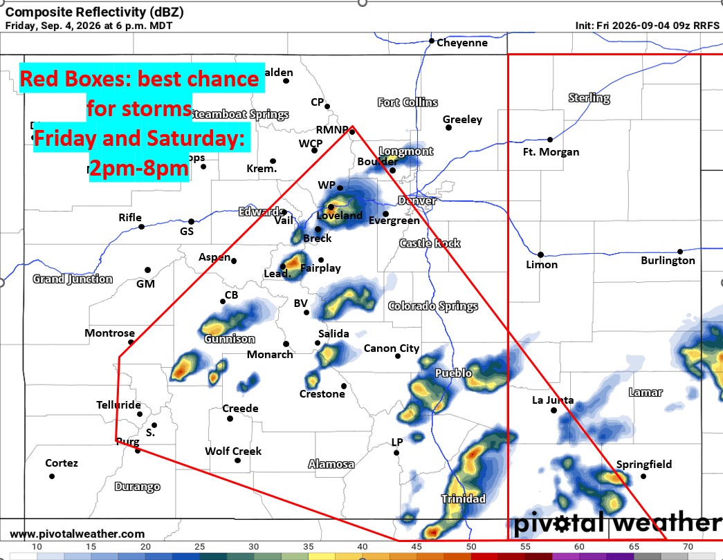
For today for the front-range (Den/Bou) and the adjacent mountains a chance for isolated to scattered thunderstorms from 3pm-9pm, best chances will come late today, after 5pm for the metro area. Best chances overall around the edges: in the foothill and near/along the Palmer Divide
Similar tomorrow but likely better chances for storms for the front-range (Den/Bou), again favoring the foothills and PD, mostly from 2pm-8pm.
After 3pm on Saturday, the eastern plains will be favored for some stronger storms in spots, mostly east of a Ft. Morgan to Limon line, 3pm-10pm (severe storms in spots).
In the mountains decent afternoon thunderstorm chances today and especially tomorrow: best chances will be east of a line from Winter Park to Vail to Telluride, so a good portion of central mountains (including Summit, ClearCreek, Grand counties etc and parts of southern CO as well).
For today in the central mountains a chance for scattered storms from 3pm-9pm, favoring areas along/eat of the Cont. Divide: locally; the Front-Range mountains will be favored after 4pm.
For tomorrow (Sat) a better chance for storms over the north-central and south-central mountains from 2pm-8pm. Mostly from Eagle county east locally. Could be some stronger storms in spots after 4pm Sat.
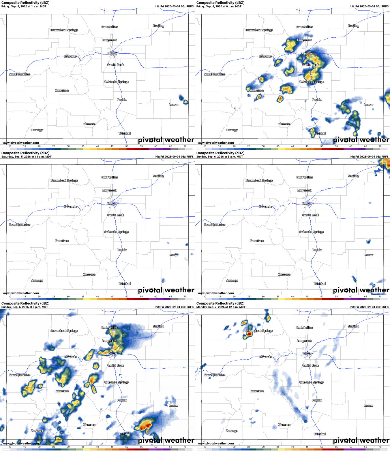
Looking ahead, a bit drier for Sun initially, but still a chance for isolated to scattered storms primarily in the mountains 3pm-9pm, this time favoring western CO, west of Vail Pass and closer to Grand Junction on Sun afternoon (as better moisture starts to rotate in, but will be west of CO initially).
By Sun evening, maybe more storms for the front-range as well, its a bit uncertain.
The weather gets more interesting for Mon as models show a deeper surge of monsoon moisture combined with a cool-front and some upslope for the front-range.
Monday will feature the best chances for storms for Den/Bou and the front-range from 2pm-9pm.
Mon will also feature a good chance for storms in the mountains as well, especially east of the Cont. Divide 1pm-8pm.
It will be cooler Mon-Wed for the front-range as well (low 80s).
We will stick with decent storm chances heading into Tue as well.
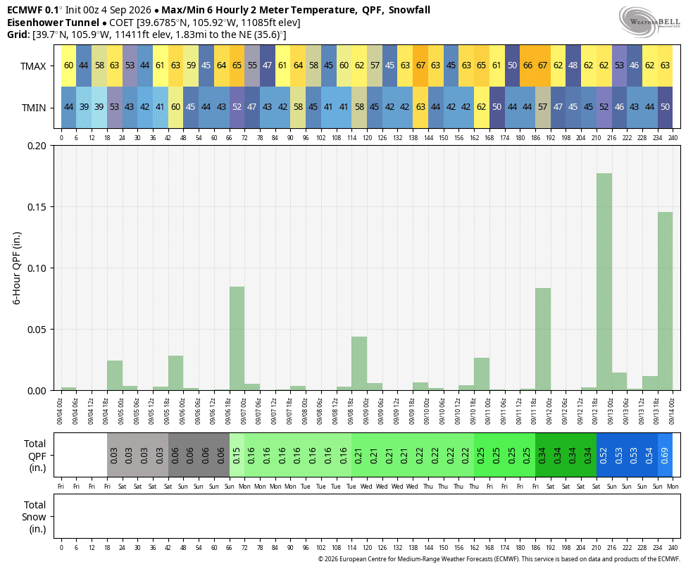
First image shows forecast radar at 6pm today from latest RRFS model, but more importantly highlights best thunderstorm chances on Fri and Sat. Second image is forecast radar over the next 84 hours (from 12am today through 12pm Mon) from latest RRFS model. Image 3 shows fore max/min temps for Boulder from latest ECMWF. Fourth image shows Max/Min 6Hr 2M Temp. + QPF(rain) for Eishenhower tunnels.
That is all for now. We are heading to the mountains Silverthorne this evening. I'll have some leaf updates from up there.
Have a great weekend.

Like what you read?
Receive daily weather reports straight to your inbox with Seth's Daily Newsletter. Sign up below.
