Forecast details for Sat and Sun and a look at the complicated forecast next week: wetter Tue-Thu
Oct 9, 2026
10/09/26 9am: Happy Friday. Quick run down of the weather coming up:
First good to see some chilly temps out there this morning (after a another warm day yesterday), especially across the mountains, where low temps were in the 20s and 30s in the mountain valleys this morning (which is expected this time of year). For example Fraser (near WP) had a low of 22. Silverthorne had a low of 33.
This is after another hot day along the front-range yesterday: for example Boulder set another daily record high yesterday of 86 degs (insane). And looks like we have another hot day in store again today: with high temps expected around 85 for Den/Bou. It cools down more noticeably by Mon/Tue and into next week. I'm so over this heat!
Aside from a few isolated storms near the Cont. Divide this afternoon (won't be much). We do have some moisture and rain moving back into the mountains for Sat into Sun.
Initially models show the chance for some rain showers across parts of the mountains tomorrow morning, favoring western / southwest CO and the central mountains 9am-12pm.
Then across much of the mountains and western CO a better chance for rain and thunderstorms on Sat into Sun: from 2pm Sat through 2am Sun: Favoring areas west of Vail Pass and along/south of I-70 for best rain chances. Elks to San Juans will be wet and chilly in spots on Sat night on Sun. Snow-level will remain mostly above 13k ft initially.
On Sun am, rain showers will continue over western CO and parts of the mountains (favoring Elks to San Juans). Some rain showers / cloudy over the north-central mountains on Sun am as well.
More rain showers and thunderstorms over western CO and the mountains on Sun: 1pm-10pm (mostly west of Vail Pass, but some along the I-70 mountain corridor).
Little to no rain expected for Den/Bou and the front-range on Sat and Sun just turning more cloudy, especially on Sun. Cooler and cloudier on Sun, maybe a chance for a late afternoon storm but not much.
Then attention turns to the more active pattern next week, but models are all over the place. It appears an upper-level low will impact CO from Tue to Thu at the very least.
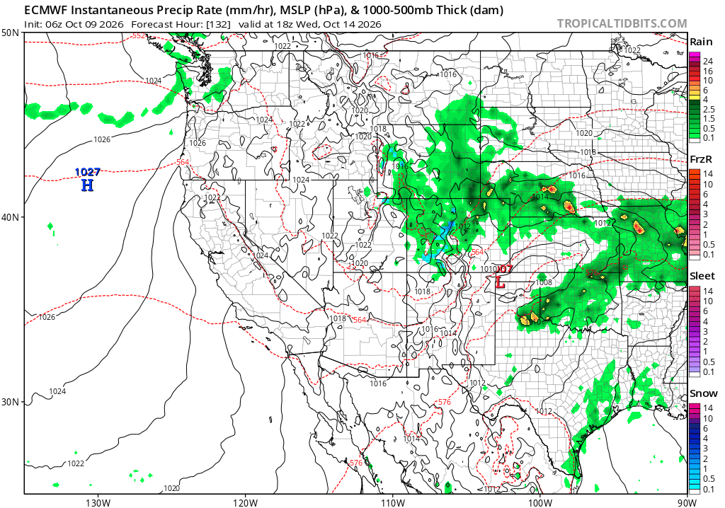
Best chances for more wide-spread rain (and snow above 11k ft) will be from 12pm Tue through 12pm Thu (with best chances on Wed).
This includes some better rain chances showing up for the front-range starting Tue afternoon into Wed afternoon.
Overall best chances for rain/snow across the state will likely be from 12pm Wed through 12pm Thu (Wed afternoon / evening will be favored). Maybe some upslope and better rain chances for Den/Bou and the front-range but will depend on low track.
Some rain/snow in the mountains Tue pm to Thu am. Snow-level will drop to around 10k ft by Wed night / Thu am with some minor accumulation in spots.
High uncertainty from Thu pm through Fri next week: some models still show a secondary storm system and cold-front (that would bring some snow chances to Den/Bou) and the adjacent mountains.
Other models don't show the second storm system developing at all (or they keep it really far north) and hence show very little precip for CO on Thu pm into Fri (that would be the latest trend and what I'm leaning towards, boo).
So you can see it will be turning somewhat active across the state, but initially favoring western CO and the mountains. Eventually maybe the front-range and parts of eastern CO by Tue-Thu but that is uncertain.
First image loop shows forecast radar over the next 48hrs (6am this morning to 6am Sun) from latest HRRR model. Second image shows the larger upper-level low to the west of CO at 12pm Tue. Third image shows forecast precip-type/rate at 12pm Wed showing some good precip across the state from latest ECMWF model.



Like what you read?
Receive daily weather reports straight to your inbox with Seth's Daily Newsletter. Sign up below.
