First snowfall map of the season! For the Tue pm to Thu am storm system
Sep 28, 2026
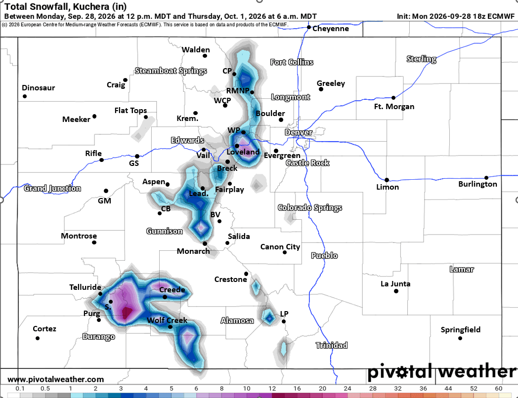
09/28/26 8pm: Its time! First snowfall map of the season! Its not going to be a ton of widespread snow (as we are still dealing with a warm storm system) but this upcoming event warranted it: as we are looking at some snow above 10,500ft, mostly tomorrow night into Thu am.
Now uncertainty in the forecast still remains high this evening as models still can't agree on low track and how much precip we will get, especially for northern CO (front-range and adjacent mountains).
My best guess about rain and snow amounts below (first image) but confidence is fairly low in the numbers. But it is just fun to get going on the snow map for this season as I know how much folks love them. I do too!
But getting some clarity: pretty clear Denver, or just north of there will be on the sharp edge of the meaningful precip. Areas from near Boulder north to Ft. Collins to the WY border are likely not going to get much (sorry Ft. Collins/Loveland/Greeley areas, this just isn't your storm). Even at my house in Westminster I'm concerned about being on the very northern edge. You can see this in the rain amounts I depicted on map.
From tonight through Tue most of the rain will be in southern CO (south of CB to BV to Springs)
Then looks like the main event is going to be basically from 11pm Tue to 6am Thu, as heavy rain fill in from south to north with snow in the mountains on Wed.
Areas near Denver and south and east can generally expect 0.50" to 2.00" of rain. Areas further north 0.10" to 0.80", with a sharp drop-off north of Boulder.
Southeast CO is still on track for 2-5" of rain in spots! And looks like much of southern CO and the San Juans will also get generally 1-3" of rain (snow up high).
As I mentioned most of the snow will be above 10,500ft (higher tonight, lower by Wed am)
Looks like heaviest snowfall overall will be in the Sangre De Cristos on Wed am into early Thu: 12-18" there (2ft+ in spots).
Also looks like parts of the San Juans (up high) could get 4-12" of new snow (on top of some already) by Thu am.
And looks like the Front Range mountains, near Eisenhower Tunnels, Loveland ski areas, Berthoud and Jones Pass, Grays/Torrey, etc will also get generally 2-8" of new snow above 10,500ft (heaviest late Wed).
That is all for now. Really hoping the more northern, ECMWF solution still pans out (18z run did come down some, I'll post that in the comments). GFS is still showing almost nothing for Den/Bou which is crazy! (I will also post in the comments).
First image is my initial snowfall (and rain) forecast map, it may change some tomorrow. Second image shows forecast total liquid precip from NWS Blend of Models, take amounts with big grain of salt but shows where best chances are for > 1" of rain. Images 3 and 4 compare forecast total snowfall from now through 6am Thu from latest RRFS model and ECMWF model, take the amounts with a grain of salt (it will change some).



Like what you read?
Receive daily weather reports straight to your inbox with Seth's Daily Newsletter. Sign up below.
