Father's Day weather, outlook for the week and for the summer season: hoping for an active monsoon
Jun 21, 2026
6/21/26 10am: Happy Summer Solstice and Happy Father's Day. I appreciate all the rad dads out there that love weather and getting after it outside 🙂 We are doing some whitewater rafting later with the family on ClearCreek, stoked on that.
Anyway, we do have some weather to talk about.
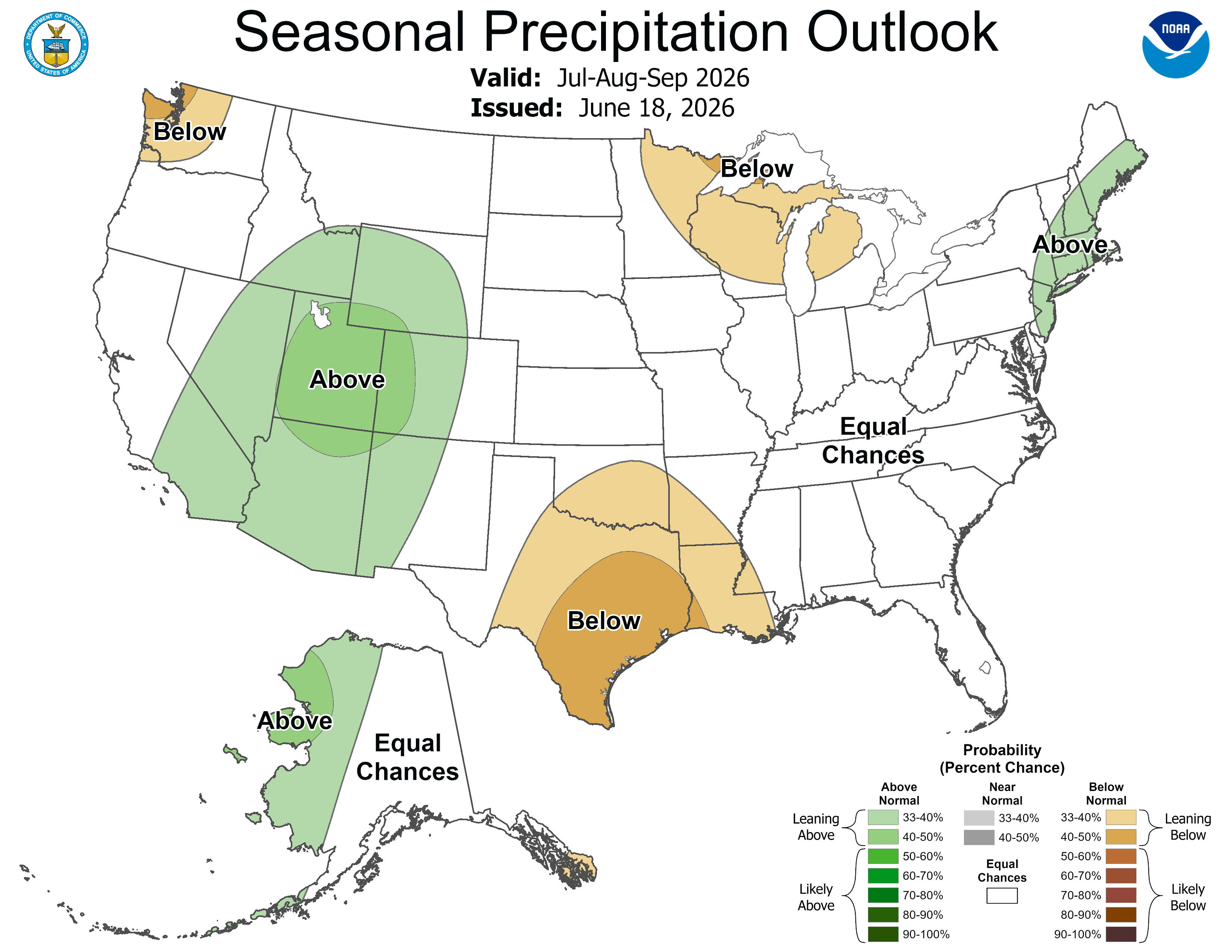
First, NCEP released its updated summer outlook for July-Aug-Sep and it shows signals for a more robust monsoon setting up later, with a chance for higher-than-average precip across parts of CO, favoring southern / western CO, hopefully, where they really need it!
For today breezy over the northern front-range with westerly wind-gusts of 20-40 mph, strongest in the foothills (hopefully won't impact our rafting too much near Idaho Springs, but breezy there).
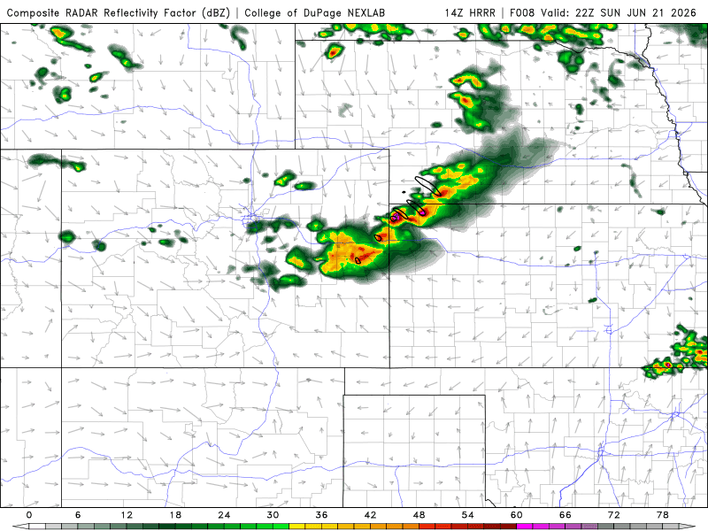
In terms of storm chances, best coverage for thunderstorms today will be near/along the Palmer Divide and south / east of there. From say Castle Rock to Springs and east / southeast of there between 1pm-9pm.
Further north for Den/Bou and the foothills, isolated weaker storms 1pm-8pm, won't be much.
Also hazy today (especially over part of the front-range). Some smoke is blowing into the state from a bigger fire burning in Utah (Iron Fire).
A stronger cold-front moves into eastern CO and down the front-range tonight after 9pm and that will bring in cooler temps and clouds initially.
Cooler on the front-range on Mon, with slightly better thunderstorm chances, but again most of the activity likely south / east of Denver tomorrow (but highs only in the 80s). Storm chances from 12pm-8pm again on Mon (favoring areas from Castle Rock to Springs to Pueblo and east).
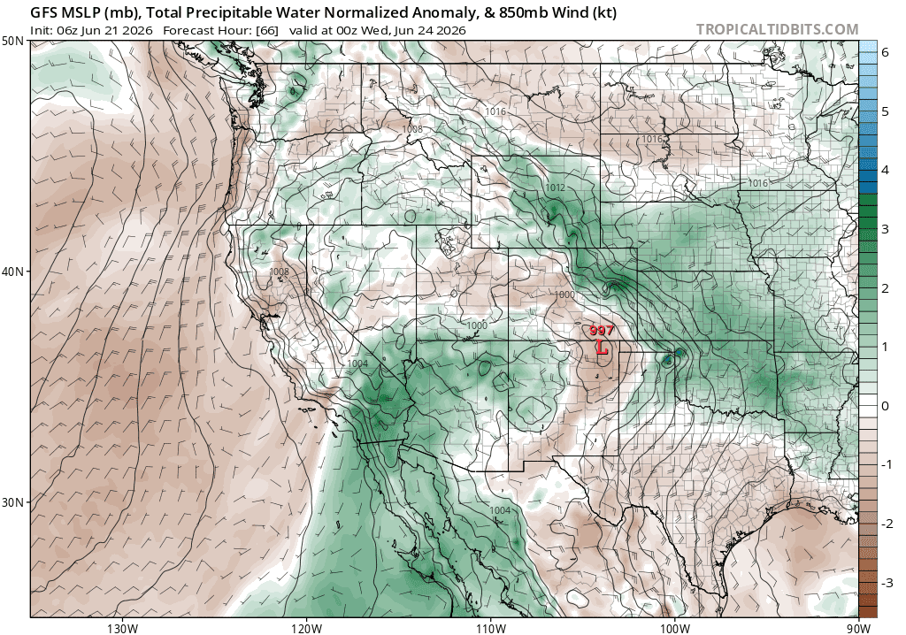
Then models show additional cold-fronts moving into the front-range / eastern CO on Tue into Wed and Wed into Thu.
Overall looks cooler and cloudier with better rain chances on the front-range for Mon-Thu this week (highs only in the low to mid-80s for Den/Bou) with a chance for storms each day primarily from 12pm-9pm, each day. Best storm chances may come Tue and Wed.
For the north-central mountains, initially limited impacts through Wed (as moisture is east), some storms east of the Cont. Divide, Mon-Wed, dry west of the Tunnels.
But then models do show an increase in monsoon-like moisture for western CO and the mountains arriving by Thu/Fri this week. So better afternoon storm chances for much of the mountains, Thu, Fri and Sat, 12pm-8pm each day, details need to be worked out.
Looking a ways out, more true monsoon-flow may get going in early / mid-July, fingers crossed for that.
First image shows the updated Seasonal Precipitation Outlook for Jul-Sep from NCEP / NOAA. Second image shows forecast radar at 4pm today from latest HRRR (some storms along the Palmer Divide and east). Third image shows the second, stronger cold-front and deeper moisture moving into eastern CO / front-range on Tue afternoon via PWAT from latest GFS.
How's your Father's Day going?

Like what you read?
Receive daily weather reports straight to your inbox with Seth's Daily Newsletter. Sign up below.