Cold temps in the mountains this morning. More cold-fronts an active weather for the front-range (Den/Bou) next week
Sep 10, 2026
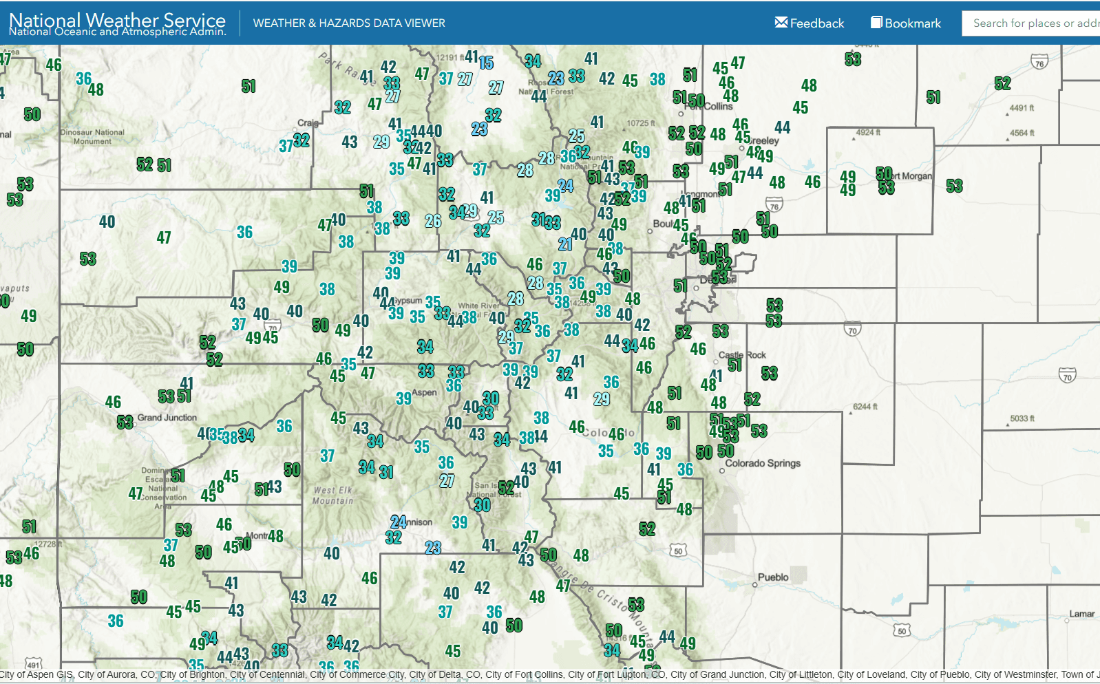
09/10/26 8:10am: Morning. A sure sign of fall: with the longer nights now, we are getting colder low temps in the morning. Getting chilly in the mountains with several areas dropping into the 20s last night. Even here in Den/Bou some low temps in the upper 40s / low 50s (officially a low of 50 at DIA).
The first image shows low temps this morning (min-T since midnight).
Here are some notable low temps (some of these are not official stations):
Cowdrey (north of Walden): 15
Fraser Flat (north of WP): 21
Gunnison: 24
Walden (airport): 27
Summit Ranch (north of Silverthorne): 28
Copper Mtn: 29
Leadville: 30
Frisco: 32
Steamboat: 32
Red Mountain Pass: 33
Jones Pass: 35
Longmont: 45
Greeley: 48
Denver: 50
Speaking of cold-fronts.... Looks active with several cold-fronts forecast for the front-range (and parts of northern CO) coming up towards the later part of the weekend into next week.
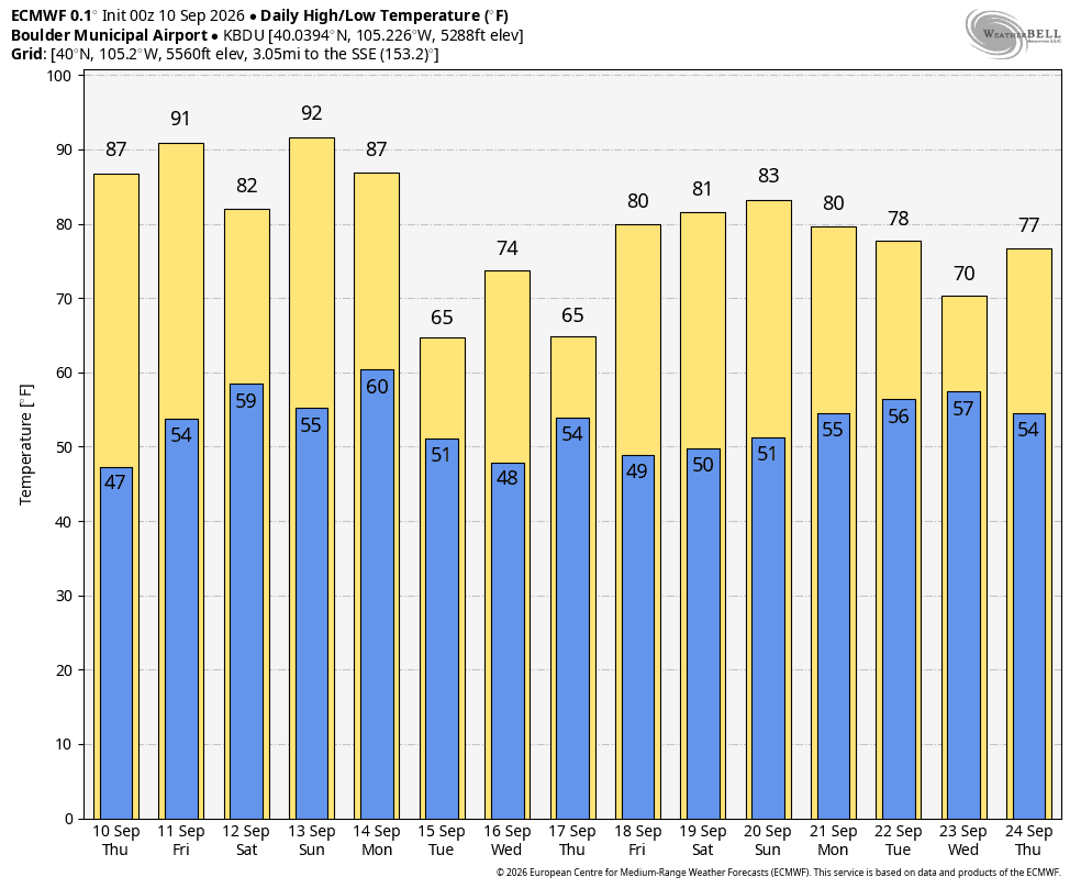
Initially hot for Den/Bou and the front-range today and Friday (low 90s).
Then a cold-front will move down the front-range (across eastern CO) on Fri night into Sat (slightly better storm chances Fri evening).
It will be cooler on Sat (highs only near 80 for Den/Bou), minimal impact in the mountains.
Then models show a stronger cold-front or series of cold-fronts impacting the front-range, eastern plains (and northern CO) Mon night into Tue (and maybe again Wed into Thu next week). This could drop temps into the upper 60s / low 70s for Tue, Wed and Thu of next week.
The cooler air will coiencide with better rain chances for both the mountains and front-range, starting Sunday and continuing through middle of next week.
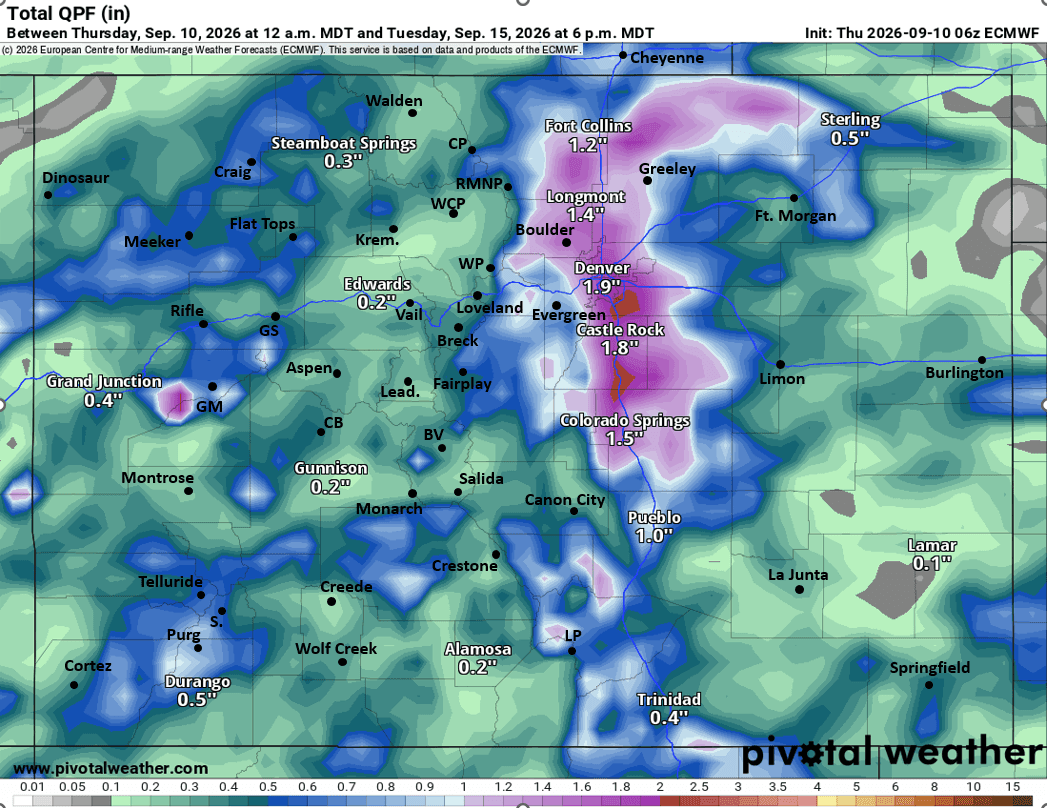
Much better rain chances Sun-Wed next week (09/13-09/16) favoring the front-range and mountains areas east of the Cont. Divide. Maybe some mountain snow for the highest elevations next week.
And looking a ways out, still looks active and maybe even cooler Sep 18-22nd, but details need to be worked out.
So some active Sep weather coming up (after we get past Sat).
First image shows low temps this morning from NWS. Second image shows forecast max/min temps for Boulder from latest ECMWF model (showing the cool down next week). Third image shows forecast total liquid precip form now through 6pm Tue (09/15) from latest ECMWF model...take with a huge grain of salt as not all models show this much rain for the front-range (but the signals are there), I'll have more later.

Like what you read?
Receive daily weather reports straight to your inbox with Seth's Daily Newsletter. Sign up below.
