Big time 72hr rainfall totals. More rain today. Very strong wind across the mountains on Sat
Jun 26, 2026
06/26/26 8:45am: Happy Friday! First lets take a look at some more impressive rain reports. Another round of heavy rain across parts the front-range and eastern CO last night.
At my house I measured an additional 0.79" of rain and that brings my 2-day total to 1.43", stoked on that. Not so stoked they had to cancel Top Taco at like 8:45 last night (well before the normal end at 10pm, oh well, I'll take the rain).
First image shows 72hr observed rainfall from MRMS that shows all the rain that fell on Tue, Wed and Thu:
Crazy to see 2.50" to 5.50" of rain over part of the eastern plains (especially near Akron and Ft. Morgan areas).
Much of Den/Bou/Ft.Collins areas have picked up 0.50" to 1.50" of rain.
Parts of the foothills have picked up 1.50" to 4.0" of rain in the last couple days, especially near Evergreen.
And also good to see 0.25" to 0.65" for a good portion of the north-central mountains including areas in Eagle, Summit and Grand counties and also over parts of western CO.
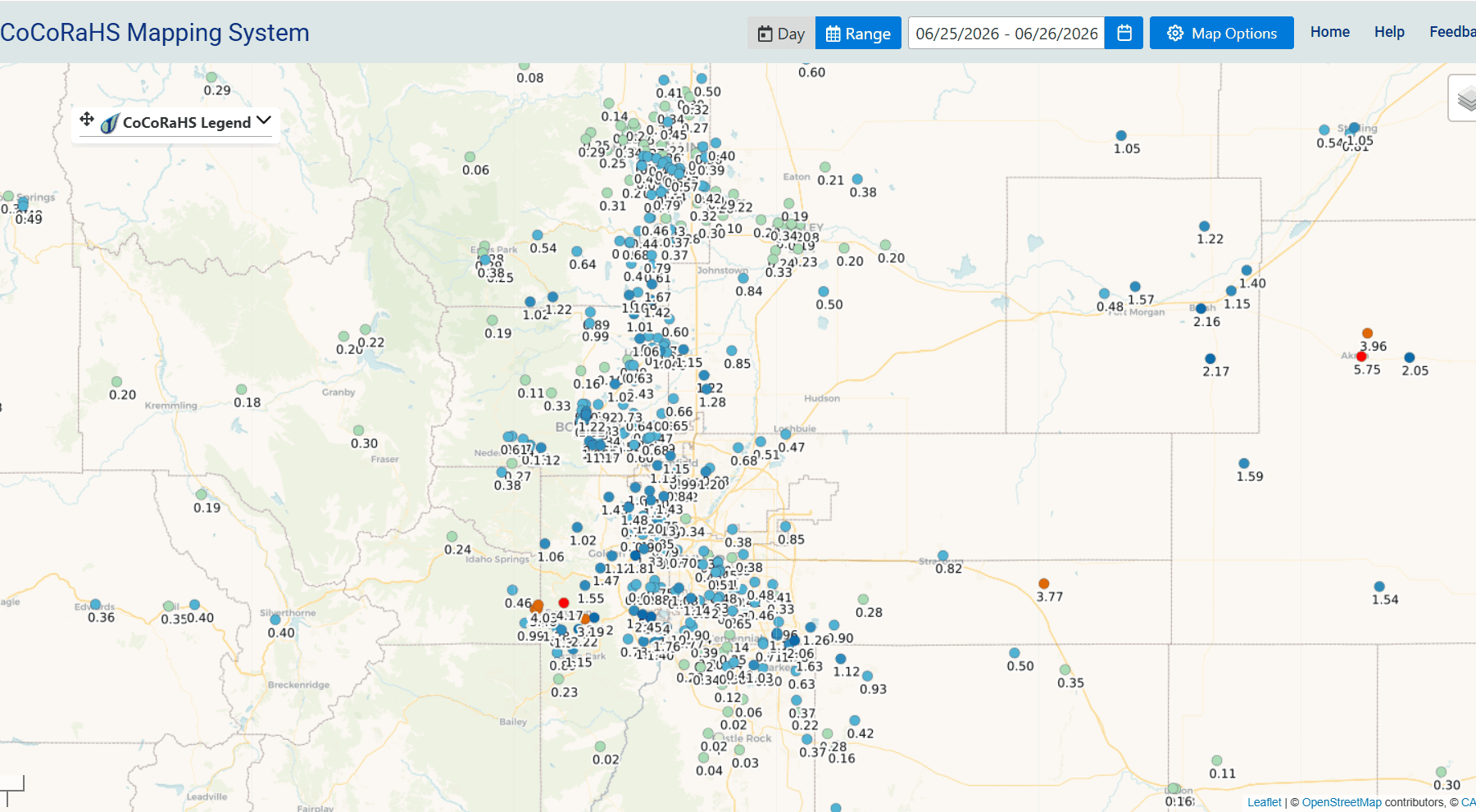
Here are some notable 48hr totals from CoCoRaHS:
Akron 0.8 ESE: 5.75"
Evergreen 1.3 NNE: 4.17"
Deer Trail 5.2 N: 3.77"
Kittredge 2.5 SSE: 3.19"
Littleton 6.3 WNW: 2.45"
Golden 3.9 E: 1.81"
Berthoud 1.0 W: 1.67"
Westminster 1.1 SW (my house): 1.43"
Thornton 2.1 N: 1.20"
Boulder 3.6 SSE: 1.17"
Denver 5.2 S: 1.14"
Longmont 2.6 NW: 1.06"
Aurora 6.6 SSE: 0.96"
Fort Collins 4.3 S: 0.79"
Nederland 2.61 NNE: 0.61"
Colorado Springs 7.4 NE: 0.54"
Silverthorne 2.8 SSW: 0.40"
Edwards 0.5 E: 0.36"
Forecast coming next:
For both the north-central mountains and the front-range (Den/Bou) another round of scattered storms from 1pm-7pm.
Rain and thunderstorms will continue over southwest CO / San Juans tonight into tomorrow am.
The big story for Saturday will be the really strong wind and high fire danger across the mountains and western CO.
It will not be a great day to climb 14ers tomorrow with expected wind-gusts of 40-70mph above 10kft between 8am-8pm tomorrow,
I'll have more on the forecast next.
First image shows 72hr observed rainfall from MRMS. Second image shows 48hr rainfall reports over Den/Bou from CoCoRaHS, third image is equivalent over northeast CO. Fourth image shows the top 24hr rain reports from yesterday.
How much rain did you get yesterday? Over the last 3 days?


Like what you read?
Receive daily weather reports straight to your inbox with Seth's Daily Newsletter. Sign up below.