
Welcome to Seth's Weather
Daily Colorado weather forecasts and consulting
Looking cold and windy for parts of the weekend with increasing snow chances for the front-range
Jan 14, 2026, 7:04 PM
01/14/26 6:50pm: Well folks its shaping up to be a pretty cold weekend and its looking cold the beginning of next week, especially for the front-range (and areas east of the Cont. Divide).
What is worse than no snow? Little to no snow and cold temps with wind...that is what we are looing at for Friday and Saturday, for the front-range and parts of the north-central mountains. Although the front-range may get some accumulating snow on Monday...
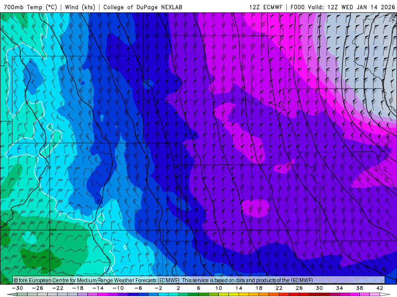
I mean we know the very cold-air is locked up just to our north and it has to come down somewhere.... very latest global model runs (like ECMWF and GFS) now show a series of cold-fronts (mostly backdoor cold-fronts coming in from the northeast), impacting CO Fri into Sat and again Sun night into Mon. Its looking chilly for Den/Bou with better snow chances. But not much snow for the mountains.
With the cold-fronts pushing in from the northeast, this is going to cause some strong pressure gradients and strong wind in/near the northern foothills at times.
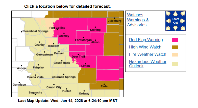
I saw that Xcel may do some preemptive power shut-offs on Friday, but looking at the forecast, best chances would be near/west of Ft. Collins and in the Boulder and Larimer county foothills above 7k ft (west, or north of Boulder as well)....those areas are under a High Wind Watch for 9am-6pm Friday.
Initial cold-front moves down the front-range after 8pm Thursday with the main shot of cold-air coming in on Friday morning. Here are some forecast details:
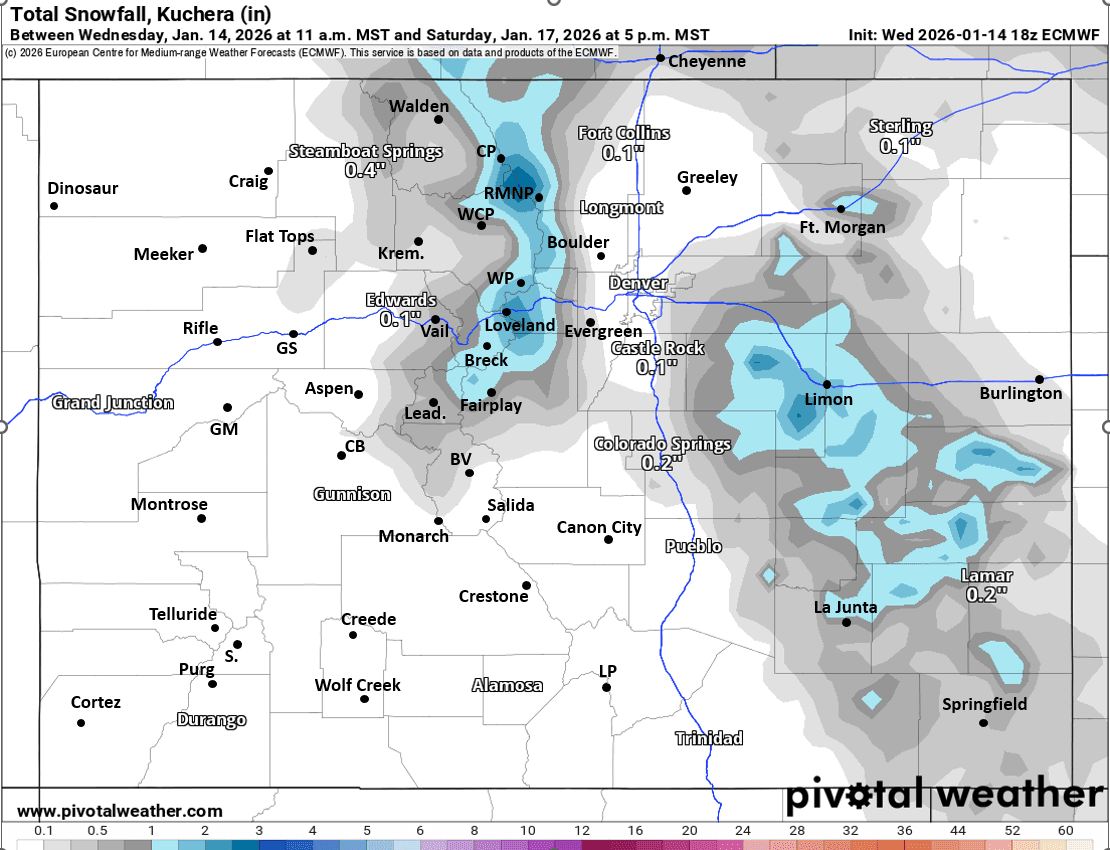
For the the north-central mountains, including I-70 mountain corridor from Summit east and the Front Range mountains a chance for snow showers / light snow primarily from 11am Fri to 2pm Sat, best chances on Fri night. Favoring Front Range mountains along/east of the Cont. Divide including Loveland ski area to Berthoud, IPW, RMNP, Cameron etc: 1-4” of snow in spots there. For areas west of the Tunnels, / local ski areas in Summit Co: Trace-2” likely by Sat, won't be much.
For the parts of the northeast plains and maybe eastern parts of Den/Bou metro area and for the Palmer Divide two chances for light snow: 2am-11am Fri (with the first main surge of cold-air). Then a better chance from 11pm Fri to 11am Sat (second surge of cold-air). Overall maybe a Trace-1" in a few spots. Going to be chilly and breezy in Den/Bou on Fri, high temps in the low 30s….
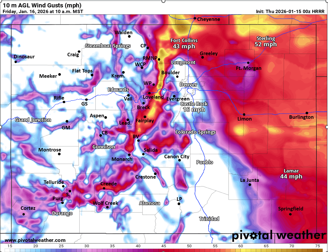
But the strongest wind on Friday will be over the northeast plains (east of a Greeley to DIA line) and also closer to Ft. Collins / WY Border, especially from 12pm-8pm on Fri: northwest wind-gusts of 30-60mph. Less wind for Den/Bou proper (gust likely under 40mph on Fri but breezy).
Very strong wind is expected over parts of the Front Range mountains and foothills mostly from Boulder county north, including Larimer county with strongest winds above 8k ft: northwest wind-gusts of 50-90 mph.
For the Broncos game on Saturday it looks chilly and a bit breezy: temps in the upper 30s, winds of 15-30 mph, partly cloudy (I guess not too bad for January lol).
In the mountains also chilly on Fri and Sat with the coldest air east of the Cont. Divide (more seasonal temps west of the Tunnels for Summit, Grand, Eagle counties). It will remain breezy in spots on Sat.
Looking ahead, models now show another shot of very cold air coming into CO from the northeast (another backdoor cold-front) on Sunday night into Monday morning. Depending on how far west the cold-air (and jet-stream) energy comes in, there could be some accumulating snow for parts of the front-range: Den/Bou/Ft.Collins, favoring areas closer to Ft. Colins and Greeley. Best chances between 2am-11am Monday, could be Trace-3" in spots.
The Front-Range mountains could get a little bit more late Sun night into mid-day Mon as well. It will also be windy again on Monday, especially along/east of the Cont. Divide.
First image loop shows the surges of coming into CO at times over the next 10 days, via 700mb temps/wind from latest ECMWF, you can see the surges on Thu into Fri/Sat and then another Sun night into Mon. Second image shows forecast total snowfall from now through 5pm Sat from latest ECMWF model, take with grain of salt. Third image shows forecast wind-gusts at 10am Fri from latest HRRR model. Fourth image shows the Red Flag Warnings for tomorrow (11am-6pm) and High Wind Watches for Friday from Den/Bou NWS office.
Seth Linden combines professional expertise with a lifelong passion for weather forecasting.
A Colorado native and avid skier, Seth turned his early fascination with weather into a career, earning degrees in Physics and Atmospheric Science from CU Boulder. For over 25 years, he has worked at the National Center for Atmospheric Research (NCAR), where he develops winter weather decision support systems for Denver International Airport and state transportation departments.
He shares his forecasting expertise through the Seth's Weather Report Facebook group, specializing in winter storm predictions.


Like what you read?
Receive daily weather reports straight to your inbox with Seth's Daily Newsletter. Sign up below.